Hochries transmitter
|
Hochries transmitter
|
||
|---|---|---|
| Basic data | ||
| Place: | Hochries mountain near Frasdorf | |
| Country: | Bavaria | |
| Country: | Germany | |
| Altitude : | 1561 m above sea level NN | |
| Coordinates: 47 ° 44'53 " N , 12 ° 14'59.7" E. | ||
| Use: | Telecommunication system , radio transmitter | |
| Owner : | German radio tower | |
| Mast data | ||
| Building material : | steel | |
| Data on the transmission system | ||
| Waveband : | FM transmitter | |
| Radio : | VHF broadcasting | |
| Send type: | BOS radio | |
| Position map | ||
|
|
||
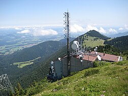
The transmitter Hochries of Deutsche Telekom AG is on 1561 m above sea level. NN on the summit house of the Hochries cable car in the Rosenheim district .
Range of the transmitter
The only frequency currently broadcast by Antenne Bayern is 107.7 MHz (transmission power: 50 kW ERP ).
The transmitter covers large parts of Upper Bavaria , Bavarian Swabia and eastern and central Lower Bavaria . The central reception region is the area around Rosenheim , Traunstein , as well as the western Chiemgau and the upper and middle Inntal, as well as the area around Miesbach, as well as the Mangfall and Leitzach valleys. With the exception of the eastern section from Traunstein / Siegsdorf, the station can be received almost continuously on the A 8 from Munich to Salzburg .
Relay station
The Hochries transmitter is used as a 4 m band relay station for the rescue service channel of the integrated control center Erding (ILS Erding). The control center area extends over the districts of Erding , Freising and Ebersberg . The southern border of the area (border of the district of Ebersberg to the district of Rosenheim) is approx. 30 km away from the transmitter, the northern border (district of Freising on the border with Mainburg in the district of Kelheim ) is approx. 100 km. The problem with the transmitter is that parts of the eastern district of Erding are not covered.
There is also a relay station on the Hochries for the fire service channel of the ILS Rosenheim. The amateur radio relay DB0TR 70cm at 438.700 MHz with 10 watts is also operated on this mast. There is also an ATV amateur radio television transmitter relay that transmits analogue just below the ASTRA satellite frequency. At 144.800 MHz, an APRS station sends the GPS location data of the radio amateurs' vehicles.
See also
Web links
- Image of the station Hochries on the website of Heinz Schulz, Frankfurt
- Hochries transmitter on www.senderfotos.de
Individual evidence
- ↑ cf. First paragraph (...) Transmitter at Hochries (...) A quick solution must be found in the dead zone. In: Süddeutsche Zeitung. December 9, 2011.
- ^ Page of the ILS Erding
- ↑ A quick solution must be found in the dead zone. In: Süddeutsche Zeitung. December 9, 2011.
- ↑ cf. (...) The relay station for the fire brigade radio is on the Hochries and thus has very good coverage for the entire radio area. In: Worth knowing about BOS-Funk FF Rott am Inn. ( Memento of the original from September 1, 2013 in the Internet Archive ) Info: The archive link was inserted automatically and has not yet been checked. Please check the original and archive link according to the instructions and then remove this notice. accessed on June 2, 2012.


