Simtany
| Simtany | ||||
|---|---|---|---|---|
|
||||
| Basic data | ||||
| State : |
|
|||
| Region : | Kraj Vysočina | |||
| District : | Havlíčkův Brod | |||
| Municipality : | Pohled | |||
| Area : | 257 ha | |||
| Geographic location : | 49 ° 36 ′ N , 15 ° 40 ′ E | |||
| Height: | 430 m nm | |||
| Residents : | 79 (2011) | |||
| Postal code : | 582 22 | |||
| License plate : | J | |||
| traffic | ||||
| Street: | Havlíčkův Brod - Přibyslav | |||
| Railway connection: | Brno – Havlíčkův Brod | |||
Simtany (German Siebentann ) is a district of the municipality of Pohled in the Czech Republic. It is located six kilometers east of the city center of Havlíčkův Brod and belongs to the Okres Havlíčkův Brod .
geography
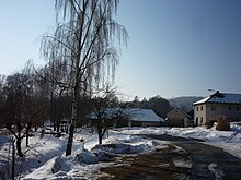
Simtany is located on the right side of the Sázava in the Hornosázavská pahorkatina ( hill country on the upper Sázava ). The village lies in the side valley of the Simtanský brook. The state road I / 19 between Rouštany and Přibyslav runs through Simtany . To the south - on the other side of the Sázava - the Brno – Havlíčkův Brod railway runs . In the north rises the Kalvárie (523 m nm), northeast of the Stříbro (509 m nm) and in the southwest of the Duškův kopec ( Wartberg , 539 m nm).
Neighboring towns are Proseč, Jilemník, U Tomu, Svatá Anna and Krátká Ves in the north, Samotín, Macourov and Zádušný Mlyn in the Northeast, Stříbrné Hory in the east, Keřkov, Štukhejlský Mlyn, U tonerů and Utin in the southeast, Dlouhá Ves and Bartoušov in the south, Mírovka and Herlify in the southwest, Pohled in the west and Kyjov and Ždírec in the northwest.
history
The village is probably founded by German miners who settled in the uninhabited border forest between Bohemia and Moravia after the silver ore was found . Sibentannen was first mentioned in writing in 1304, when the Cistercian convent Vallis Sancta Mariae acquired the village. After that, the village always remained in the monastery property.
In 1782, Emperor Joseph II abolished the Frauenthal monastery and assigned the Frauenthal estate to the religious fund. Until 1807 the property was administered by the Imperial and Royal Bohemian State Property Administration, after which it was publicly auctioned and sold to Count Joseph von Unwerth. After his death in 1822 Eugen Graf Silva-Tarouca-Unwerth inherited the property.
In 1840 the village of Siebenthan or Siebentann in the Caslauer Kreis consisted of 24 houses in which 172 predominantly German-speaking people lived. The parish was Frauenthal . Until the middle of the 19th century, the village of Siebenthan , which was part of the Iglauer Sprachinsel, remained subject to Gut Frauenthal and Termeshöfen .
After the abolition of patrimony , Siebentann / Simtany formed from 1849 a district of the municipality of Pohled or Frantál in the judicial district of Deutschbrod . From 1868 the place belonged to the district Deutschbrod . In 1869 Simtany had 168 inhabitants and consisted of 26 houses. In 1900 there were 203 people in Simtany, in 1910 there were 190. In 1930 Simtany had 136 inhabitants and consisted of 29 houses. In the 2001 census, 80 people lived in the 34 houses in the village.
Community structure
Simtany includes the layers U Tomů and Svatá Anna.
The district forms a cadastral district.
Attractions
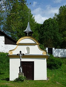
- Chapel of the Virgin Mary, built in the middle of the 18th century. It was renovated in 2013.
- Sanctuary of Svatá Anna
literature
- Historický lexikon obcí České republiky 1869–2005 , part 1, p. 556
Web links
Individual evidence
- ↑ http://www.uir.cz/katastralni-uzemi/724653/Simtany
- ^ Johann Gottfried Sommer : The Kingdom of Bohemia; Represented statistically and topographically. Volume 11: Caslauer Kreis. Ehrlich, Prague 1843, p. 182.
- ↑ http://www.uir.cz/katastralni-uzemi/724653/Simtany


