Şırnak
| Şırnak | ||||
|
||||
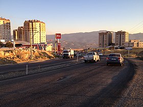
 Sirnak in the evening light, in the background the Cudi mountain range |
||||
| Basic data | ||||
|---|---|---|---|---|
| Province (il) : | Şırnak | |||
| Coordinates : | 37 ° 31 ' N , 42 ° 28' E | |||
| Height : | 1650 m | |||
| Residents : | 62,761 (2018) | |||
| Telephone code : | (+90) 486 | |||
| Postal code : | 73,000 | |||
| License plate : | 73 | |||
| Structure and administration (as of 2019) | ||||
| Structure : | 12 Mahalle | |||
| Mayor : | Mehmet Yarka ( AKP ) | |||
| Website: | ||||
| Şırnak County | ||||
| Residents : | 93,431 (2018) | |||
| Surface: | 1,701 km² | |||
| Population density : | 55 inhabitants per km² | |||
Şırnak ( Kurdish Şirnex) is a city in the Turkish region of Southeast Anatolia . At the same time, it is the capital of the province founded in 1990 and the district of the same name. The district town ( Merkez ) unites around 67 percent of the population of the entire district.
The district is next to the district town from three other municipalities ( Belediye :) Kasrik (3186), Balveren (3457) and Kumçatı (9,287 pop.). In addition, there are 18 villages ( Köy , plural Köyler ), with an average population of 776 inhabitants per village. Six villages have over 1,000 inhabitants, including Yenİaslanbaşar (2,858) and Kizilsu (2,479).
Şırnak is a very old city, the first signs of settlement go back several millennia. Before the conflict in 2016, the city had 63,047 inhabitants (2014 census), the majority of whom were Kurds . The city is located near the border triangle Turkey / Syria / Iraq in a mountainous region. To the south of Şırnak is Mount Cudi and to the west is Mount Gabar . Şırnak lies at 1,350 meters above sea level and has no historical building fabric.
Şırnak has had Şerafettin Elçi Airport, which Turkish Airlines flies to, since 2013 .
According to a popular etymology, the name Şırnak is said to be derived from Şehr-i Nuh , which means Noach's city . This then became Şerneh and then Şırnak . Mount Cudi applies to the Koran as Anlegeort of Noah's ark . The derivation of the Armenian word Sirunak ("beautiful") is controversial.
Conflicts between the Turkish military and the PKK
1992
On August 18, 1992 fighting broke out between the Turkish police and the military on one side and the PKK on the other. The military bombed the city and most of the residents fled. When the fighting ended after three days, around 150 deaths were counted.
2016
In the course of the Turkish offensive against the PKK in Southeast Anatolia , which has been ongoing since 2015 , the fighting also reached Şırnak in March 2016. The fighting was accompanied by a curfew, which lasted 246 days from March 14, 2016 and was lifted in November 2016. Most of the residents left the city during the fighting and returned - at least partially - after the fighting ended.
According to the Turkish Ministry of Environment and Urban Development, 14,727 houses were damaged and 2,044 buildings were demolished in the course of the fighting, which led to the disappearance of entire city districts. According to former HDP MP Leyla Birlik , 70% of the city has been demolished. Districts that were actually not in the combat zone were also affected.
Population development
The following table shows the comparative population level at the end of the year for the province, the central district and the city of Şırnak as well as the respective share at the higher administrative level. The figures are based on the address-based population register (ADNKS) introduced in 2007.
| year | province | district | city | ||
|---|---|---|---|---|---|
| real | percent | real | percent | real | |
| 2018 | 524.190 | 17.82 | 93,431 | 67.17 | 62,761 |
| 2017 | 503.236 | 17.00 | 85,557 | 64.23 | 54,955 |
| 2016 | 483,788 | 17.05 | 82,468 | 65.52 | 54.032 |
| 2015 | 490.184 | 18.81 | 92.206 | 68.72 | 63,367 |
| 2014 | 488.966 | 18.73 | 91,573 | 68.85 | 63,047 |
| 2013 | 475.255 | 18.35 | 87,187 | 69.11 | 60,255 |
| 2012 | 466.982 | 18.78 | 87,719 | 72.16 | 63,298 |
| 2011 | 457.997 | 18.64 | 85,369 | 71.85 | 61,335 |
| 2010 | 430.109 | 18.10 | 77,865 | 69.69 | 54.263 |
| 2009 | 430.424 | 20.21 | 87,000 | 73.18 | 63,664 |
| 2008 | 429.287 | 19.30 | 82,863 | 71.73 | 59,435 |
| 2007 | 416.001 | 18.81 | 78.231 | 69.41 | 54,302 |
Climate table
| Şırnak (1350 m) | ||||||||||||||||||||||||||||||||||||||||||||||||
|---|---|---|---|---|---|---|---|---|---|---|---|---|---|---|---|---|---|---|---|---|---|---|---|---|---|---|---|---|---|---|---|---|---|---|---|---|---|---|---|---|---|---|---|---|---|---|---|---|
| Climate diagram | ||||||||||||||||||||||||||||||||||||||||||||||||
| ||||||||||||||||||||||||||||||||||||||||||||||||
|
Average monthly temperatures and precipitation for Şırnak (1350 m)
|
||||||||||||||||||||||||||||||||||||||||||||||||||||||||||||||||||||||||||||||||||||||||||||||||||||||||||||||||||||||||
Individual evidence
- ↑ a b Türkiye Nüfusu İl ve İlçelere Göre Nüfus Bilgileri (Nufusune.com) , accessed on April 23, 2019
- ↑ Christopher de Bellaigue: Rebel Land, page 231
- ↑ Mehmet Aksoy - KurdishQuestion.com. Accessed March 31, 2019 .
- ↑ How the Turkish army and Kurdish fighters reduced this town to ruins. Accessed March 31, 2019 .
- ↑ 70% of Şırnak has been demolished. Accessed March 31, 2019 .
- ↑ Central Dissemination System / Merkezi Dağıtım Sistemi (MEDAS) of the TÜIK , accessed on May 5, 2019


