Skardu (district)
|
Skardu district ضلع سکردو |
|
| State : |
|
| Province : | Gilgit-Baltistan |
| Founded : | July 1, 1970 |
| Seat : | Skardu |
| Coordinates : | 34 ° 0 ′ N , 73 ° 0 ′ E |
| Area : | 15,000 km² |
| Residents : | 214,848 |
| Population density : | 14 inhabitants per km² |
| Time zone : | PST ( UTC + 5 ) |

|
|
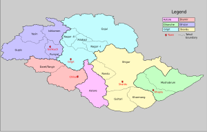
The Skardu District is one of seven districts of the Gilgit-Baltistan Autonomous Region (formerly Northern Areas ) in Pakistan . The district is located in the southeast of the Karakoram on the upper reaches of the Indus , east of Hunza and Gilgit district , west of Indian Ladakh and north of the western Himalayas .
The Skandu district is a barren high mountain landscape with four mountains over 8000 m altitude. In the city of Skardu is the headquarters of the Skardu district.
history
The founder Skardus was the last Buddhist ruler Bokha (the mute), who was replaced by Islamization in the 15th century. Skardu was then split up by independent absolute rulers who ruled and fought or allied in the various valleys. From 1842 they were ruled by the Hindu Dogras from Kashmir . The people of Baltistan , the Balti people in particular from Skardu, were against this foreign rule and therefore joined Pakistan in 1947 . The abolition of local principalities took place in 1972.
economy
Traditional cultivation of barley , millet and buckwheat is practiced in the Skardu district . Livestock farming consists of goats, sheep, chickens, yaks (Tibetan cattle) and dzos (cross between yak and lowland cattle ). Since it rains little, planting can only take place in the fields of the fertile alluvial land of the tributaries of the Indus or on artificially developed and irrigated mountain terraces. Winter is long and harsh, with average temperatures of -10 ° C, but can also drop to -25 ° C.
Besides the Gilgit district, the Skardu district is an important area for trekking , expeditions and tourism in the Gilgit-Baltistan region. The four eight-thousanders and a high mountain landscape in this district are visited by tourists from April to October. In winter, the district is partially cut off from the outside world, as the passes can be icy and destroyed by avalanches.
The town of Skardu is the starting point for tourists and mountaineers, where their supply and goods needs can be met and where accommodation is available.
Location and transport links
The Skardu district borders in the east on the Ghanche district , in the southeast on the Kargil district , in the northeast it reaches the border with China, on Xinjiang . In the west lies the Astore district , in the south the Baramulla district and in the north the Skardu district borders on the Gilgit district .
The Skardu district can be reached via a road from the Karakoram Highway through the Skardu Valley. The Gilgit district is approached via the Hispar pass , which, however, is not passable for nine months. There are also road connections to Kashmir and Ladakh . The city of Skardu can be reached via its own airport, Skardu Airport .
Ethnicities and religion
The Balti, Pashtuns , Panjabers , Hunzukuc and Uighurs who are of Muslim faith live in this district . But there are also people from other tribes who came to this district, such as those who emigrated from Tibet and Afghanistan , for example .
The religion was that of the Buddhists until 500 years ago , evidence here is the Buddha rock in Skardu, before that there was the Bon religion. Now about 70% are Shiites who were proselytized from Kashmir, 25% Nurbakshis , 4% Sunni of the proselytized Wahhabis from Saudi Arabia who pursue their faith in the mosque in Skardu.
landscape
In the Skardu district there is a typical high mountain landscape. The Deosai National Park with an area of about 3000 km², which is located on a high plateau at an altitude of 4100 m, is the second highest national park in the world, after the Changthang in Tibet . Snow leopards , ibex , Himalayan bears and wild horses live in the Skardi district .
There are several lakes such as Upper Kachura Lake, which is near the town, and the more famous Lower Kachura Lake .
Mountains, glaciers and rivers
In Skardu District is the Karakorum . The highest mountain in the Skardu district is the K2 with 8611 m in the Baltoro Muztaghn . Other high mountains are the Broad Peak with 8047 m, the main peak of Gasherbrum I with 8080 m, Gasherbrum II with 8034 m and the Masherbrum with 7821 m.
The Biafo Glacier , the Baltoro Glacier and most of the Hispar Glacier are part of this district. The Indus divides the Skardu district into two parts, which in this district is fed by tributaries such as the Braldu River .
Cities and passes
The cities in this district are next to Skardu Shigar , Rondu , Kharmang , Parkutta and Gultari , which is close to India on the Line of Control . The high mountain passes that lead into the Skardu district are the Hispar pass, the only pass that connects with the Gilgit district, and the Gondoghoro pass , these are only unpaved slopes that are only accessible by four-wheel drive vehicles .
Web links
Individual evidence
- ↑ a b c Information on rzuser.uni-heidelberg.de , accessed on December 30, 2009


