
Carefully at Weißenhasel
|
Carefully at Weißenhasel
|
||
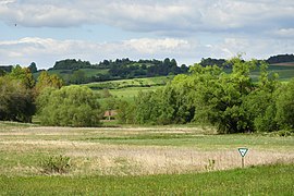
.jpg) View from the north-westerly towards the reserve and the Gerlachsmühle. |
||
| location | South of Weißenhasel in the Hersfeld-Rotenburg district in East Hesse . | |
| surface | 6.95 hectares | |
| Identifier | 1632012 | |
| WDPA ID | 165602 | |
| Geographical location | 51 ° 2 ' N , 9 ° 56' E | |
|
||
| Setup date | 1986 | |
| particularities | Special protection as a nature reserve . | |

The Sorgwiesen near Weißenhasel are a small wetland area in the Hasel valley between Nentershausen and Weißenhasel in the Hersfeld-Rotenburg district in eastern Hesse . After the abandonment of agricultural use, the wet fallow land with its plant communities was designated as a nature reserve in order to secure and protect the area that had become a habitat for amphibians and bird species.
Geographical location
The Sorgwiesen are in the Weißenhasel district of the Nentershausen community in the Hersfeld-Rotenburg district. In the east they are bordered by state road 3249 and in the west by a cycle path. The protected area consists of two partial areas, which are separated from each other by an industrial plant and the property of the Gerlachsmühle.
In terms of natural space , the area is assigned to the “ Sontraer Land ” in the “ Fulda-Werra-Bergland ” in the main unit group “ Osthessisches Bergland ”.
Protected position
With the designation as a nature reserve, by ordinance of November 20, 1986 of the District Directorate for Forests and Nature Conservation at the regional council in Kassel , the "fallow wet meadows rich in typical plant communities as habitat for endangered bird and amphibian species" should be secured and preserved. The protected area with a size of 6.95 hectares has the national identifier 1632012 and the WDPA code 165602.
nature
.jpg)
The upper, smaller area of the two-part nature reserve is a strip of wet wasteland that has been preserved between the country road and the hazel stream. The lower area begins north of the Gerlachsmühle. The hazel runs through the protected area in a ditch about two meters wide, with a few trees that accompany the stream. In addition to the brook, there are extensive spring outlets in the wet meadow area , where butterbur stocks have developed. More water-bearing ditches run through the area.
The source of the hazel rises south of Bauhaus , at an altitude of around 400 m in the wooded natural area of the Solztrotten Forest . Its mouth, as the right tributary of the Sontra , is northwest of Hornel . Outside the villages, the small stream flows largely straightened through meadowland. The upper course of the stream, as well as its tributaries, have only minimal water flow at times and periodically fall dry.
The cultivated peripheral areas of the Sorgwiesen consist of fresh pasture and meadow communities. The much larger central area developed into damp to wet fallow land overgrown with swamp sedges after it was no longer used . Smaller areas are occupied by slender sedges , cane grass and reeds and also by tall herbaceous meadows with meadowsweet and swamp cranesbill .
To those in the area detected amphibians and reptiles include mountain lizard , slow worm , frog , toad , salamander , mountain , pond and palmate newt . The area is a breeding area for snipes and has an important stepping stone function for migratory birds .
Tourist development
There are no roads through the narrow protected area. But it can be seen from the main road and the bike path.

View from the west.
The northern area of the two-part nature reserve.
.jpg)
.jpg)
literature
- Lothar and Sieglinde Nitsche, Marcus Schmidt: Nature reserves in Hessen , Volume 3, cognitio Verlag, Niedenstein 2005. ISBN 3-932583-13-2 .
Web links
Individual evidence
- ↑ The Gerlachsmühle is located 1.2 km south of Weißenhasel near the Oberhasel desert, after which it is also called the Oberhaseler Mühle.
- ↑ Classification of natural areas according to Otto Klausing in the Hessen Environmental Atlas at atlas.umwelt.hessen.de ; accessed on May 21, 2019.
- ↑ Quoted from the ordinance on the nature reserve “Sorgwiesen bei Weißenhasel” of November 20, 1986 in the State Gazette for the State of Hesse, edition 49/1986 of December 8, 1986, p. 2349 f.
- ↑ "Sorgwiesen at Weißenhasel" in the world database on protected areas; accessed on May 21, 2019.
- ↑ a b Lothar and Sieglinde Nitsche, Marcus Schmidt: Nature reserves in Hessen, Volume 3 . Pp. 187 and 188.
- ↑ Albrecht Ensgraber: Hessen new nature reserves in birds and the environment , Journal of Ornithology and Nature Conservation in Hesse, Volume 5, Issue 2, pages 84 and 85. Wiesbaden, July 1988th


Old Fulda near Asbach | Old Fulda near Bad Hersfeld | Old Fulda near Blankenheim | On the reed near Iba | Bruchwiesen near Mengshausen | Buchenberg, Grisselborn woods and Taftgrund near Soisdorf | Dachsberg near Iba | Dreienberg near Friedewald | Forbachsee near Bebra | Haselgrund near Schwarzenhasel | Hirtenwiese am Eisenberg | In the sand near Rotenburg | In the pastures near Blankenheim | Jossaaue near Breitenbach am Herzberg | Gravel pit near Baumbach | Landecker Berg near Ransbach | Moor near Wehrda | Obersuhler Aue | Rhaden near Obersuhl and Bosserode | Pool of pipes of herrings | Säulingssee near Kleinensee | Schwärzelsberg-Langeberg-Grasburg | Careful at Weißenhasel | Stöckig-Ruppertshöhe | Ulfewiesen near Weiterode | Ulsterwiesen near Mansbach | Under the seal at Bebra | Wacholderberg and Schmiedsberg near Dens