
Haselgrund near Schwarzenhasel
|
Haselgrund near Schwarzenhasel
|
||
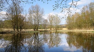
.jpg) Marsh marigold meadow and Seggenried in the northern area. |
||
| location | Between Schwarzenhasel and Lispenhausen in Hesse Hersfeld-Rotenburg . | |
| surface | 23.2 hectares | |
| Identifier | 1632020 | |
| WDPA ID | 163541 | |
| Geographical location | 51 ° 1 ' N , 9 ° 46' E | |
|
||
| Sea level | 220 m | |
| Setup date | December 1991 | |
| particularities | Special protection as a nature reserve . | |

The Haselgrund near Schwarzenhasel is a floodplain area between Schwarzenhasel and Lispenhausen in the Hersfeld-Rotenburg district of Hesse . The damp meadows as well as the reeds and sedges in the Haselgrund provide a habitat for rare plant and animal species. In order to protect the area and improve it through extensification and renaturation, it was designated as a nature reserve in December 1991 .
Geographical location
The nature reserve is located in the districts of Schwarzenhasel and Lispenhausen of the city of Rotenburg an der Fulda in the district of Hersfeld-Rotenburg. It is bounded to the west by state road 3226 . In the east, a cycling and hiking trail and the Riedelsmühle property form the border. The name of the earlier grinding and grist mill, which is also called Obere Mühle, suggests that this area used to be swampy and a large reed.
The floodplain is traversed by the Hasel , an approximately 12 km long stream. It rises west of the Mosenberg in the Stölzinger Mountains and flows into the Fulda on the right at Lispenhausen .
In terms of nature , the Haselgrund is assigned to the " Haselbach-Bebra-Bergland " in the " Fulda-Werra-Bergland " of the " East Hessian Mountains ".
Protected position
With the ordinance of the regional council in Kassel of December 11, 1991, the Haselaue south of Schwarzenhasel was declared a nature reserve under the name "Haselgrund bei Schwarzenhasel". The purpose of the protection was to preserve the partially moist meadow meadows with their reeds and sedge beds as a habitat for rare plant and animal species and to improve the area through extensification and renaturation. The protected area has a size of 23.2 hectares, has the national identification 1632020 and the WDPA code 163541.
nature
In the valley area of the floodplain, groundwater emerges, partly as an artesian well . The water leakage is caused by the water-blocking clay layers stored in the subsoil . The water has low temperatures and a high content of iron and mineral salts . In earlier times the entire floodplain was used as grassland . Since the end of the 19th century, the area had been significantly changed with straightening the hazel and fortifying its banks with stones, filling in the wet and wet meadows and draining in almost all areas. Later fish ponds and a Christmas tree culture were created in Haselgrund.
.jpg)
In order to regenerate the floodplain, various measures followed in several sections: A small still water body was created at the point where soil deposits had spilled source areas . The Haselbach was partially renatured with a meandering course. On former grassland that had fallen fallow because it could no longer be driven on with today's machines, the formation of reeds was allowed.
Birds such as the reed bunting are characteristic species in the reserve . Their habitats are reed beds and sedges . The tall herb , fallow land and groups of trees prefer the irregular breeding field and even more rarely-heard Warbler . Evidence of the corncrake who built his nest in used and fallow meadows is older. Moorhen , water rail and mallard breed at the designed pond . Notable regular guests are the gray heron , teal , red and black kite , common snipe , kingfisher and red backed killer .
Amphibians such as common frogs , green frogs , common toads and crested newts find suitable spawning grounds in the pond and at the springs. Insects, like the 15 proven dragonfly species , prefer the pond to lay their eggs. The grass snake also lives here.
An inventory of the plants at the end of the 1980s revealed 126 species in the area. The occurrence of the endangered swamp trident , which is dependent on mowed damp meadows, as it cannot survive in fallow land , was considered significant . The extensive stocks of marsh marigolds and the common butterbur , which grows profusely on wet areas with seepage springs, are no longer common in the region. The marsh marigold meadows with interspersed sedge meadows have developed on extensively used areas in the north. There is a larger population of the swamp locust here, which avoids fallow wet meadows.
The newly created pond.

Part in the lower Haselgrund.
.jpg)
.jpg)
Tourist development
The protected area can be seen clearly from state road 3226 in the west and from the cycling and hiking trail on the other side. The Hessian long- distance cycle route R5 leads along this path from Willingen to Wanfried .
literature
- Lothar and Sieglinde Nitsche, Marcus Schmidt: Nature reserves in Hessen. Volume 3, cognitio Verlag, Niedenstein 2005, pp. 171 and 172. ISBN 3-932583-13-2 .
Web links
Individual evidence
- ↑ Hans Knothe: "Some from the history of my home village Lispenhausen" ; accessed on May 8, 2019.
- ↑ Classification of natural areas according to Otto Klausing in the Hessen Environmental Atlas at atlas.umwelt.hessen.de ; accessed on May 8, 2019.
- ^ Ordinance on the nature reserve "Haselgrund bei Schwarzenhasel" of December 11, 1991 in the State Gazette for the State of Hesse, edition 52/1991 of December 30, 19913, p. 2986 f.
- ^ "Haselgrund bei Schwarzenhasel" in the world database on protected areas; accessed on May 8, 2019.
- ↑ a b c Lothar and Sieglinde Nitsche, Marcus Schmidt: Nature reserves in Hessen, Volume 3. P. 171 f.
- ↑ Quoted from the text on the information board on the edge of the protected area.


Old Fulda near Asbach | Old Fulda near Bad Hersfeld | Old Fulda near Blankenheim | On the reed near Iba | Bruchwiesen near Mengshausen | Buchenberg, Grisselborn woods and Taftgrund near Soisdorf | Dachsberg near Iba | Dreienberg near Friedewald | Forbachsee near Bebra | Haselgrund near Schwarzenhasel | Hirtenwiese am Eisenberg | In the sand near Rotenburg | In the pastures near Blankenheim | Jossaaue near Breitenbach am Herzberg | Gravel pit near Baumbach | Landecker Berg near Ransbach | Moor near Wehrda | Obersuhler Aue | Rhaden near Obersuhl and Bosserode | Pool of pipes of herrings | Säulingssee near Kleinensee | Schwärzelsberg-Langeberg-Grasburg | Careful at Weißenhasel | Stöckig-Ruppertshöhe | Ulfewiesen near Weiterode | Ulsterwiesen near Mansbach | Under the seal at Bebra | Wacholderberg and Schmiedsberg near Dens