
City fortifications (Erkelenz)
The city fortification of Erkelenz is a medieval fortification of the city of Erkelenz that is still preserved today . It was considered impregnable: 14 defensive towers were set into the 1.6 kilometer long city wall with its four gates, each of which represented a gate castle . In the run-up to her there was a double moat separated by a wall .
In the years 1816 to 1819 the city fortifications, which had meanwhile become inoperable, were largely put down. Restored parts of the castle on the north promenade and the city wall on Wallstrasse still exist today in the mid-1950s . The medieval city fortification has shaped the pear-shaped expansion of the city center to this day due to four promenade streets that were laid over the wall foundations that were still in the ground, and a green belt over the filled trenches.

Components
Castle
Coordinates: 51 ° 4 ′ 55 ″ N , 6 ° 18 ′ 57 ″ E

Although the castle is only mentioned in a document in 1349, the city presumably had a lighter wall when it was granted city rights in 1326, which had begun in the 11th century. In addition, the castle has obviously been included in the city wall, so that it should have been present when the city charter was granted in 1326. It is also hardly to be assumed that an unfortified place was elevated to a city.
The castle was only accessible from the city. Rainald IV, Duke of Geldern († 1423), when the castle tower was built in 1423, planned to provide access to the fields for himself and his men without being dependent on the opening and closing of the city gates . His successor Arnold von Egmond , however, had to commit to the citizenship that the access that had already begun would be bricked up again and never reopened. The castle was the seat of the bailiffs , garrison and arsenal.
The simple brick tower , which fell into ruin before its restoration, was popularly known as the Hexenturm , measures 23 meters in height on a square floor plan with a side length of 13 meters and is 3.50 meters thick at the bottom. From the elevated courtyard ago, he has over a basement, which as a torture chamber has served three upper floors, each with a window to every direction, small light window in the spiral staircase and an abortion - bay two upper floors on. The adjacent castle wall with loopholes is 11 meters high on the field side and has a roofed battlement over pointed arcades on the castle side .
On the city side, too, the castle had smaller towers and a drawbridge over a moat. The lower part of such a tower can still be seen here. Next to it is the so-called Wolfsturm , more of a rectangular tower stump, which was the above-ground castle dungeon on the city side, but door and windowless , into which the prisoners were lowered from the castle courtyard through a round hole in the middle of the ceiling ("holed"). The tower was so named because the howling and wailing of the prisoners there reminded of those of the wolves . Finally, one of the former 14 defensive towers is still present in the castle and city walls.
Gates
It took around 160 years to build the fortifications in the city, which is located on two crossing old trade and military routes . In 1355 the inner Brückor (Brückstrasse) was built from stones from the destroyed robber baron's castle Gripekoven , in 1416 the inner Maartor ( Aachener Strasse), 1420 the inner Oerather ( Roermonder ) Tor (Roermonder Strasse), 1454 the outer Oerather Tor, 1459 the outer one Maartor, in 1495 the bridge at the Brückor and in 1514 the outer Bellinghovener (Kölner) Tor (Kölner Strasse). Only then was the fortification of the city completed.
Each gate in itself was a multi-storey gate castle, the powerful foundations of which reached up to five meters into the ground and with an enclosed courtyard ( kennel ) and a front gate were directed more than 30 and 40 meters towards the field. They were provided with small towers and defensive corridors protected by roofs with loopholes and housed armories as well as the guard rooms and the gatekeepers' apartments.
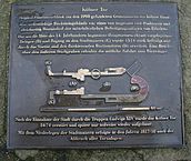
- Bronze floor plates with explanations of the gates of the city fortifications

Reconstruction of the bridge gate

Maartor floor plan

Reconstruction of the Oerath Gate
Floor plan Kölner Tor


Wall

There is no written evidence of the construction of the city wall, which was on average 8.5 meters high on the outside. It had 15 wall towers, including the one mentioned as part of the castle, which is still standing today, two each on Wallstrasse between Burg and Brückstrasse and on the east promenade between Brückstrasse and Bellinghovener Tor and five each on the south promenade between Bellinghovener Tor and Maartor, including one Mill tower , as well as on the west promenade between Maartor and Oerather Tor. The mill tower built in 1423 at the Maartor was incorporated into the city wall, so that it was obviously only built here after this time.
Like the castle and gates, the towers and walls were built of bricks and provided with loopholes. On the city side, a battlement with battlements ran over pointed arcades up past the wall . At the bottom of the wall, a path ran around the city, onto which the streets and alleys ran in a star shape from the city center, so that the wall and towers could be reached within a minute for the defense teams in the city.
The distance between the towers was around 70 meters. Therefore, the defensive fire from two towers overlapped and was able to catch the enemy in the flank . They had no stairs to the individual floors , only holes in the middle of the ceiling, through which the crews climbed on retrievable ladders and pulled shooting supplies and provisions on ropes up to the top floor or let down from there. In this way, in the event of a defense, they could withdraw from floor to floor and hold out for a long time.
Not far from the castle there is still a piece of the defensive path with the Wallstraße with larger remnants of the former city wall and a gap in between where one of the defensive towers stood. When the city wall no longer served its purpose, small houses on the city side leaned against them and left chimneys in them .
Canal

A double moat ( canal ), about 40 meters wide, was in front of the city's fortifications . The steep slope angles led to a depth of 5 meters, where, due to the lack of flowing water in the urban area, rainwater drained from the maar collected via open gutters and canals under the wall and formed a muddy mass, which is why it was called the black canal . The maar was located at the lowest point in the city on today's Franziskanerplatz and, with a side length of 52 by 55 meters and a depth of 3 meters, was a considerable water reservoir , in which rainwater collected and which also served as a fire water pond and cattle trough.
When Karl von Egmond (1492–1538) had the Erkelenz fortress restored in the 16th century , the defensive measures of gates, towers and walls were pushed forward with the emerging artillery in order to keep attackers as far away from the city as possible. The wall was widened and masonry casemates were built inside . Such a casemate, popularly called the black cellar , was cut during earthworks in 1956 on the edge of the outer canal in front of the castle tower.
The end
The end of fortress Erkelenz was initiated during the Dutch War , when the army of the French king Louis XIV together with the troops of the Archbishop of Cologne bombarded the city gates with cannons for hours on May 9, 1674 . The citizens who awaited the attack had recruited several officers under the Prince of Croy for defense . The fortifications of the Bellinghovener Tor seem to have been even stronger than those of the Oerather Tor and withstood three assaults. It was not until the fourth attack that evening that they fell. 400 deaths are said to have occurred among the attackers, 6 among the defenders.
Two days later the conquerors blew up the Bellinghovener Tor and the Oerather Tor and forced the citizens to break through the walls, one next to the Bellinghovener Tor, one next to the Maartor, one on today's Zehnthofweg and one by the castle opposite the Pangel.
Later, the city fortifications seem to have been restored, albeit in a makeshift manner and only for a while, as documented by written evidence from the years 1695 and 1718. In particular, the entertainment was less for fortification and more for fiscal reasons, because the excise , a direct tax, was collected at the city gates, which no one could escape as long as all roads into the city led exclusively through the city gates.
When the city became Prussian in 1815 , the walls had already collapsed in some places or were in danger of collapsing, so the government in Aachen asked the city either to repair all masonry from a historical perspective or to demolish it. In spite of the fear that with the demolition of the city walls the town charter could also be lost, the town council decided to demolish it for cost reasons. To finance it, the land and stones were sold and the trenches filled in.
Todays situation

The only reminder of the former city gates today are bronze floor plates with floor plans and explanations attached by the local history association of the Erkelenzer Lande at the corresponding locations, which are integrated as stations in a signposted historical city tour . A wide strip of green stretches across the leveled canal from the former Maartor to the castle. To the east of the castle, the green areas give way to a large parking lot. On the east promenade, a parking deck made of bricks with arches and semicircular tower projections symbolizes the course of the old city wall. Across the street, a small residential street in Erkelenzer Platt has been given the name Schwatte Jräet (black canal).
On August 19, 2016, the Friends of the Castle Association put a roof on the castle tower. It is a 16 by 16 meter wooden structure covered with zinc and is intended to protect the walls from moisture. Presumably the tower already had a roof in the Middle Ages. From the years 1500/1501 there is an invoice that mentions the purchase of 14,000 Leysteenen ( leystones or slabs) and 20,000 Leynagel (nails).
Individual evidence
- ↑ http://www.aachener-zeitung.de/lokales/heinsberg/ein-dach-fuer-die-burg-massarbeit-mit-dem-300-tonnen-kran-1.1429810
- ^ Ernst von Oidtman : Invoice report on renovation work on the castle and city fortifications of Erkelenz 1500 - 1501, in magazine of the Aachener Geschichtsverein 34, 1912
literature
- Josef Gaspers, Leo Sels u. a .: History of the city of Erkelenz . Erkelenz 1926, p. 2ff and P. 152ff.
- Friedel Krings: The medieval fortifications of the city of Erkelenz. In: Home calendar of the Erkelenzer Lande. Erkelenz 1957, p. 55 ff.
- Institute for historical regional studies of the Rhineland at the University of Bonn (Ed.): Rheinischer Städteatlas . III No. 15, Cologne 1976, p. 2 ff.
- Josef Lennartz: The complaint of Franz Schaeven and the end of the city wall. In: Writings of the Heimatverein der Erkelenzer Lande. Volume 1, Erkelenz 1981, pp. 20ff.
- W [ilhelm] Pinkemeyer: Erkelenz as a fortress. War history from ancient times; a contribution to awakening and promoting the love of home and explained by reconstruction plans of the old fortifications . Erkelenz, self-published, 1913
- Peter Schönfeld: New findings on the Erkelenz city fortifications. The archaeological investigations at the Brückor 2015 , in: From the history of the Erkelenzer Land. With 12 contributions by 10 authors , writings of the Heimatverein der Erkelenzer Lande e. V. No. 30, Erkelenz 2015, ISBN 978-3-9815182-8-3 , pp. 12-37