Steinegg (municipality of Altenburg)
|
Steinegg (Rotte) village Steinegg cadastral community Steinegg |
||
|---|---|---|
|
|
||
| Basic data | ||
| Pole. District , state | Horn (HO), Lower Austria | |
| Pole. local community | Altenburg | |
| Coordinates | 48 ° 37 '37 " N , 15 ° 33' 37" E | |
| height | 302 m above sea level A. | |
| Residents of the village | 44 (January 1, 2020) | |
| Area d. KG | 2.95 km² | |
| Post Code | 3591 | |
| prefix | + 43/02987 | |
| Statistical identification | ||
| Locality code | 03901 | |
| Cadastral parish number | 10059 | |
| Counting district / district | Steinegg (31101 002) | |
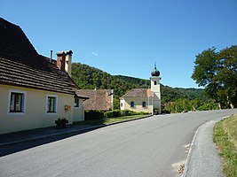
 Local chapel of Steinegg |
||
| Source: STAT : index of places ; BEV : GEONAM ; NÖGIS | ||
Steinegg is a place and a cadastral municipality in the municipality of Altenburg (Lower Austria) in the Horn district in Lower Austria .
geography
The place is in the Kamptal between Rosenburg and Wegscheid . The altitude in the town center is 302 meters. The area of the cadastral community covers 2.95 km². The population is 48 (as of 2001).
Population development
| year | 1794 | 1830 | 1869 | 1951 | 1961 | 1971 | 1991 | 2001 |
|---|---|---|---|---|---|---|---|---|
| Residents | 106 | 95 | 90 | 56 | 50 | 51 | 46 | 48 |
history
The place was first mentioned in 1210 when a Kolo von Steinekke owned the castle. In the 14th century it was owned by the Lords of Maissau and in 1428 it passed to Duke Albrecht V of Austria . Probably in the same century it fell into ruin.
At the end of the 19th century, Steinegg developed into a small summer resort . After 1945 the place could no longer connect to this. Changed travel habits, but also the construction of the Kamptal reservoirs, which led to a sharp drop in temperature in the Kamp, which is lined with numerous bathing establishments, deprived tourism in the Kamptal of its most important foundations.
Culture and sights
- Steinegg ruins
The ruin can be reached from the Gasthaus zur neue Welt (Dunkler) via the main road towards St. Leonhard. At house no. 13 (former ruin landlord) you reach the ruin on the right via a wooden footbridge and a short steep path. Remains of the keep and the main castle with arched windows have been preserved.
Economy and Infrastructure
traffic
The place is on the state road 8044 from Fuglau to St. Leonhard am Hornerwald . The place is not connected to public transport . The closest ÖBB train station is Rosenburg an der Kamptalbahn .
literature
- Josef Krelowetz: Steinegg. In: Das Waldviertel 24th vol., H. 1-3 (1975), pp. 20-22.
- Franz Rauscher: The Reithmühle near Steinegg am Kamp. In: Das Waldviertel 1. Jg., H. 10 (1952), pp. 10-14.
- Renate Seebauer: Historical journey through seven centuries. Altenburg - Burgerwiesen - Fuglau - Mahrersdorf - Steinegg. LIT, Vienna 2016. ISBN 978-3-643-50722-8
Individual evidence
- ↑ Historisches Ortlexikon Niederösterreich ( Memento of the original dated November 5, 2010 in the Internet Archive ) Info: The archive link was inserted automatically and not yet checked. Please check the original and archive link according to the instructions and then remove this notice. (PDF; 1.2 MB), part 2, p. 34.
- ^ Franz Eppel: The Waldviertel. His works of art, historical forms of life and settlement. 8th edition, Salzburg 1984, p. 214. ISBN 3-900173-01-X
- ^ Susanne Hawlik: Summer vacation in the Kamptal. The magic of a river landscape. Vienna-Cologne-Weimar 1995. ISBN 978-3-205-98315-6 .
- ↑ Ruin Steinegg on altemauern.info


