Stolzalpe (mountain range)
| Pride alpe | |
|---|---|
|
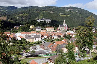
Southwest flank of the Stolzalpe over Murau , with the settlement of Stolzalpe |
|
| Highest peak | Stolzalpe ( 1817 m above sea level ) |
| location | Upper Murtal ; Murau , Styria |
| part of | Stolzalpe Group , Schladminger Tauern / Murberge / Murauer Berge |
| Coordinates | 47 ° 9 ' N , 14 ° 11' E |
| surface | 70 km² |
| particularities | With Nickelberg |
The Stolzalpe is 1817 m above sea level. A. high mountain range of the Niedere Tauern in the Upper Mur Valley , Styria .
Location and landscape
The Stolzalpe rises near Murau to the north in the Mur valley , between Rantental in the west and Katschtal in the east and north.
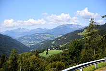
The Stolzalpe is a loosely wooded, low mountain range up to the summit area . She stands in isolation; the Krakow - Schöder - Oberwölz line , the Murparalleltal , separates the Murberg train from the main massif of the Niedere Tauern. The side valleys of the Mur line here in an easterly to south-easterly direction, the massif has a west-east extension of 14½ kilometers. It rises more than 1000 meters above the Murtal. The mountain is considered to be particularly sunny due to its small-scale, protected location.
Classification, boundary, structure and summit

The Stolzalpe is included in the Schladminger Tauern , an east-west section of the Niedere Tauern. Orographically it forms an extension of the Rupprechtseck ( 2591 m above sea level ) south of the Tauern main ridge. Locally, it is one of the Murberg Mountains , the mountain range of the Niedere Tauern that lies in front of the Murberg . After the mountain group Breakdown by Trimmel owned group of Stolzalpe as part of the Murau mountains already geological reasons the Noric Alps .
In the northwest, via Schöderbach near Schöder and Baierdorf, it forms the boundary to the ridge of the Schöderkogel , also on the Tauern main ridge. In the north, the Katschbach at Feistritz separates from the foothills of the Rettelkirchspitze , which - located east of the Sölkpass - already belongs to the Wölzer Tauern , and from St. Peter via Althofen to the confluence at Katsch and Frojach (approx. 752 m above sea level. ) from the Eichberg and Pleschaitz massif. In the south the Gurktal Alps border on the Mur via Triebendorf to Murau with the massifs of the Blasenkogel and Karchauer Ecks and the Frauenalpe . The Kramerkogel of the Murberge rises to the southwest . To the northwest, the valley pass separates Schöder – Rottenmann (approx. 940 m above sea level ) from the lower Talberg Staberkogel (Freiberg).
The massif is divided into star-shaped valleys. The southern ridge stretches over Mur in the Laaser Höhe (Hasenstein approx. 1550 m , main summit 1442 m above sea level ) to the east and down to Katsch. The climatic health resort of Stolzalpe is located on the southwest shoulder towards the Mur valley . The east ridge stretches between Laasen and Glanz in the Katschtal near Althofen and Peterdorf . The west ridge runs over Planitzen and Vorderberg into the Rantental. The north ridge leads to St. Peter. To the north-west of the Wassermannbach - Rineggbach - Niklbergbach line are the Mittelberg ( 1501 m above sea level ) at Rinegg , and then the Nickelberg ( 1528 m above sea level ) between Hinterberg and the middle Katschtal.
geology
The massif is mainly a metamorphic Old Paleozoic , which does not belong to the Old Crystalline of the Lower Tauern, but to the Gurktal Nappe of the Upper Eastern Alps ( Murau Paleozoic ) .
The bulk is vulkanitischer Diabasschiefer (chlorite slate ) with intercalated clay layers ( Ordovician - Silurian , about 450 million years). These belong to the Stolzalpendecke , the higher partial ceiling of the Gurktaler blanket, which gave the Stolzalpe its name. Underneath, there are scaly layers of the Permotrias (floodplain group; Gutenstein base series, around 250 million years) near Murau. At the base near Murau and Katsch lies Murauer Kalk ( Devonian , around 400 million years), which belong to the deeper Murau ceiling . The underlying carbon phyllite (as on the Kramerkogel) can be found in the Katschtal. There the foot of the mountain is black mica slate , which already belongs to the Middle Eastern Alps of the Niedere Tauern main mass and forms the base of the basin of the Murau Paleozoic. Marbles from the Murauer Kalkgruppe are also stored here on the Nickelberg .
Development and ways
The massif offers numerous forest walks. The Salzsteigweg (Austrian long-distance hiking trail 09) and the Styrian state circular hiking trail cross the Stolzalpe from St. Peter to Murau.
Web links
Individual evidence
- ↑ Stolzalpe. AEIOU-Austria-Lexikon (Link to the Austria-Forum leads to the community article, status 2019).
- ↑ A. Thurner: Geology of the Stolzalpe near Murau. In: Mitt. Naturwiss. Association for Styria , Volume 64/65, Graz 1929.
- ^ Franz R. Neubauer: The structure of the Old Palaeozoic south and west of Murau (Styria / Carinthia). In: Janrb. Geol. Bundesanstalt 122 (1979), pp. 455-511.
- ^ Franz R. Neubauer: The geology of the Murauer area - research status and problems. In: Mitt. Abt. Geol. Palaont. Bergb. Landesmus. Joanneum issue 4, Graz 1980 ( pdf , opac.geologie.ac.at).
- ↑ Peter Holl: Niedere Tauern: a guide for valleys, huts and mountains. Bergverlag Rother GmbH, 2005, p. 165.
