
Stuthof
|
Stuthof
City of Rostock
|
|
|---|---|
 |
|
| Area : | 5.7 km² |
| Residents : | 74 (December 31, 2017) |
| Population density : | 13 inhabitants / km² |
| Incorporation : | July 1, 1950 |
| Postal code : | 18146 |
| Area code : | 0381 |
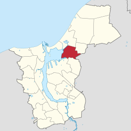  Location of Stuthof in Rostock
|
|
Stuthof is a district of Rostock . It is located in the northeast of the Breitling in the Rostock-Ost urban area, which is very rural overall. Stuthof is located on the southwestern edge of the Rostock Heath . The Stuthof district includes Schnatermann , a former forester's shop and now an excursion restaurant on the Breitling.
history
Old maps mention a settlement of the stüdthoff , which is seen as a reference to horse breeding. In 1769 Stuthof is mentioned as being owned by the city of Rostock. The place is called in 1868 as a "combing". The farm was leased at the time, and there was a school in Stuthof for the local children and from Jürgeshof .
Until 1922, Stuthof formed a rural community together with Jürgeshof, Schnatermann and Purkshof . Then Jürgeshof and Purkshof came to the community of Mittel-Rövershagen (the name for the central part of Rövershagen at that time ). For this purpose, Niederhagen , a district of Rövershagen before 1922 and after 1950, was added to the municipality of Stuthof. Schnatermann came to the city of Rostock two years later. In 1930 Stuthof had 73 inhabitants, 96 people lived in the Niederhagen district.
In 1950 Stuthof was incorporated into Rostock.
freetime and recreation
Excursion destinations are the stables in Stuthof and the Schnatermann , a hotel-restaurant in the forest with an outdoor area and a harbor for boat tours.
traffic
Stuthof is located north of Landesstraße 22 and can be reached with Rostock bus lines 16 and 18. In the summer season excursion boats operated from Schnatermann to Warnemünde and Markgrafenheide.
Web links
Individual evidence
- ↑ Statistics office of the city of Rostock: Population with main residence of the Hanseatic and university city of Rostock by district - as of December 31, 2017
- ^ Karl Koppmann , Contributions to the History of the City of Rostock , Volume 2, in the commission of the Stiller'schen Hof- u. University Bookstore, 1895, p. 29.
- ^ Anton Friderich Büsching , magazine for the new history and geography, volume 3 , Verlag Johann Nicolaus Carl Bucheröders and Compagnie, Hamburg 1769, p. 102, online (Google Books).
- ^ Archive for regional studies in the Grossherzogthümen Mecklenburg , eighteenth year, Verlag der Hofbuchdruckerei von AW Sandmeyer, Schwerin 1868, p. 250, online (Google Books).
- ^ Government Gazette for Mecklenburg-Schwerin , year 1922, p. 315.
- ^ Frank Mohr, Gregor Stentzel, Landkarten - Zeitbilder: Rostock and surroundings in the course of time; Notes on Maps from Five Centuries. , Edition Temmen, Bremen 2001
- ↑ Keywords Schnatermann, Stuthof and Niederhagen, in: Mecklenburgisches Ortsverzeichnis 1930, Cities and Towns of the States Mecklenburg-Schwerin and Mecklenburg Strelitz , Verlag Boldt, 1930.
Biestow | Brinckmansdorf | Diedrichshagen | Dierkow-Neu | Dierkow-Ost | Dierkow-West | Evershagen | Garden city / city pasture | Gehlsdorf | Big small | Hansaviertel | Hinrichsdorf | Hinrichshagen | High dune | Jürgeshof | Kröpeliner-Tor-Vorstadt | Krummendorf | Lichtenhagen | Lütten Klein | Markgrafenheide | Nienhagen | Peez | Reutershagen | Schmarl | City center | Stuthof | Südstadt | Toitenwinkel | Peat bridge | Warnemünde | Wiethagen .