Sulejów
| Sulejów | ||
|---|---|---|

|
|
|
| Basic data | ||
| State : | Poland | |
| Voivodeship : | Łódź | |
| Powiat : | Piotrków Trybunalski | |
| Area : | 26.25 km² | |
| Geographic location : | 51 ° 20 ′ N , 19 ° 48 ′ E | |
| Height : | 166 m npm | |
| Residents : | 6190 (Jun. 30, 2019) |
|
| Postal code : | 97-330 | |
| Telephone code : | (+48) 44 | |
| License plate : | EPI | |
| Economy and Transport | ||
| Street : | Łódź - Kielce | |
| Next international airport : | Łódź | |
| Gmina | ||
| Gminatype: | Urban and rural municipality | |
| Gmina structure: | 35 localities | |
| 25 school offices | ||
| Surface: | 188.24 km² | |
| Residents: | 16,314 (Jun. 30, 2019) |
|
| Population density : | 87 inhabitants / km² | |
| Community number ( GUS ): | 1010093 | |
| Administration (as of 2007) | ||
| Mayor : | Stanislaw Baryla | |
| Address: | ul.Konecka 42 97-330 Sulejów |
|
| Website : | www.sulejow.pl | |
Sulejów [ su'lɛjuf ] is a city in Poland in the Łódź Voivodeship . It is the seat of the town and country municipality of the same name in the powiat Piotrkowski . Barkowice Mokre also belongs to the municipality .
history
The first written mention of the place comes from the year 1145. In 1177 Cistercian monks settled in the area and built the local monastery Sulejów . The town received its town charter between 1279 and 1292. In 1313 Władysław I. Ellenlang gave the town the right to trade in salt , meat and cloth . In 1388 Władysław II gave Jagiełło Sulejów the right to a weekly market , every Wednesday. With the third partition of Poland , the place became part of Prussia in 1795 . With the formation of the Duchy of Warsaw , the place became part of the same in 1807 and part of Congress Poland in 1815 . The Cistercian monastery was closed four years later. In 1870 a reform of the city law on Polish soil was carried out by Tsar Alexander II , in which the number of cities was reduced from 452 to 114. Sulejów was one of the towns that lost their town charter. In 1899 the planning of a narrow-gauge railway to Piotrków Trybunalski began . The railway began operating in 1904. In 1927 the place was given city rights again. During the German invasion of Poland , Sulejów was bombed by the Luftwaffe on September 4, 1939 . A ghetto was established in 1942 and a forced labor camp from 1944–1945. At the end of the war the place was 80% destroyed.
Population development
In 2004, 3,186 men and 3,126 women lived in the city.
local community
In addition to the city of Sulejów, the following 25 districts with a Schulzenamt belong to the urban and rural community:
- Barkowice
- Barkowice Mokre
- Biała
- Bilska Wola
- Bilska Wola-Kolonia
- Kałek
- Klementynów
- Kłudzice
- Koło
- Korytnica
- Krzewiny
- Kurnędz
- Łazy-Dąbrowa
- Łęczno
- Nowa Wieś
- Podlubień
- Poniatów
- Przygłów
- Uszczyn
- Witów
- Witów-Kolonia
- Włodzimierzów
- Wójtostwo
- Zalesice
- Zalesice-Kolonia
Other localities in the municipality are:
- Adelinów
- Dorotów
- Karolinów
- Łazy
- Mikołajów
- Piotrów
- Podkałek
- Salkowszczyzna
- Winduga
Town twinning
- Tišnov , Czech Republic
Culture and sights
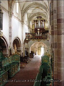
- The Romanesque monastery church of St. Thomas was consecrated in 1232, and construction began in 1177.
- The adjoining former Cistercian monastery with bastions and partly Romanesque outer walls.
- The neo-Gothic church of St. Florian dates from 1903.
- The cemetery chapel dates from the first half of the 19th century.
- The baroque church of Saint Margaret .
Web links
- City website (Polish, English)
- Website of the monastery
Individual evidence
- ↑ a b population. Size and Structure by Territorial Division. As of June 30, 2019. Główny Urząd Statystyczny (GUS) (PDF files; 0.99 MiB), accessed December 24, 2019 .
- ↑ http://www.inter.media.pl/nt-bin/sulejow/start.asp?page=ludnosc ( page no longer available , search in web archives ) Info: The link was automatically marked as defective. Please check the link according to the instructions and then remove this notice.

