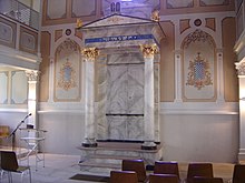
Sulzburg synagogue
The synagogue in Sulzburg , a small town in the Breisgau-Hochschwarzwald district in southwest Baden-Württemberg , was built in 1821/22 and devastated during the November pogroms in 1938 . The secular synagogue is located in today's Gustav-Weil-Straße (formerly Mühlbachstraße), which was named after the orientalist Gustav Weil who was born in Sulzburg .
history
The formation of the Jewish community in Sulzburg goes back to the 16th century. The synagogue building that still exists today was built according to the plans of the architect Johann Ludwig Weinbrenner , a nephew of the well-known Baden architect Friedrich Weinbrenner . It was built in a late Baroque - Classicist mixed style. In the years 1876/77 the synagogue was renovated and a ritual bath ( mikveh ) was installed in the basement .
After the synagogues in Karlsruhe and Randegg, the synagogue in Sulzburg was the third synagogue building in what was then the Grand Duchy of Baden and is now the only synagogue from Friedrich Weinbrenner's architecture school that has not been destroyed.
architecture
The rectangular synagogue building has a gabled Doric portico above the entrance and a recessed niche for the Torah shrine on the east wall . On each of the long sides there are five twin windows raised by a round arch and above five round windows at the height of the gallery. The three-sided women's gallery can be reached through two wooden spiral staircases inside the building. Above the pediment two are off sandstone manufactured bid sheets attached.
time of the nationalsocialism
“ The synagogue was badly demolished during the November pogrom in 1938. More information about the events on that day in Sulzburg is available from the trial files of the Second Criminal Chamber of the Freiburg Regional Court. During this trial on December 15, 1947, the former Müllheim district leader Hugo Grüner was convicted as the mastermind behind the actions in absentia. As early as the afternoon of November 9, 1938, the Heitersheim gendarmerie station, to whose post area Sulzburg belonged, had received an order from the Müllheim Gendarmerie District to summon all officers to the town hall in Sulzburg at 8 a.m. the next morning. Before 6 a.m. on the morning of November 10th, a number of those involved in the pogrom, including two Gestapo officers from Müllheim, drove into Sulzburg. District leader Grüner also appeared together with some "political leaders" and announced that something had to be done against the Jews. Between 7:00 and 7:30 am, several omnibuses from Westwall workers came to Sulzburg to carry out the "Jewish raid". After the Jewish men had meanwhile been arrested and taken to the town hall, the Siegfried Line workers broke into the Jewish houses and began their work of destruction and looting. All Jewish houses as well as the synagogue and the Jewish school were badly damaged and looted. Fortunately, the synagogue could not be set on fire because the neighboring houses were too close. In 1939 the political community purchased the synagogue building. A gym should be set up in it. At times, however, the building was used as a depot for the Freiburg University Library. After the war, the building was confiscated and initially returned to the Jewish community of South Baden via the JRSO Jewish property management company. In 1954 it was sold to a private person for commercial purposes. After that, the former church was used as a storage room and factory hall. "
Todays use
After the extensive restoration work was completed, the former synagogue was opened as a meeting place in 1984 . There are cultural events and exhibitions in the building.
The synagogue is open on the first and last Sunday of the month from 4 p.m. to 6 p.m., during exhibitions every day.
See also
literature
- Klaus-Dieter Alicke: Lexicon of the Jewish communities in the German-speaking area. 3 volumes. Gütersloher Verlagshaus , Gütersloh 2008, ISBN 978-3-579-08035-2 .
- Joachim Hahn and Jürgen Krüger : Synagogues in Baden-Württemberg . Volume 2: Joachim Hahn: Places and Facilities . Konrad Theiss Verlag , Stuttgart 2007, pp. 469–472, ISBN 978-3-8062-1843-5 ( Memorial book of the synagogues in Germany . Volume 4).
- Jost Grosspietsch: Sulzburg . In: Franz-Josef Ziwes (Hrsg.): Baden synagogues from the time of Grand Duke Friedrich I in contemporary photographs . G. Braun, Karlsruhe 1997, ISBN 3-7650-8177-9 , pp. 40-41.
Web links
- Sulzburg synagogue near Alemannia Judaica (with many old and new photos)
- The synagogue near the city of Sulzburg (accessed on February 16, 2014)
Individual evidence
Coordinates: 47 ° 50 ′ 29 " N , 7 ° 42 ′ 30.3" E


