
Twiste Viaduct
Coordinates: 51 ° 27 ′ 50 ″ N , 9 ° 7 ′ 7 ″ E
| Twiste Viaduct ( Twiste valley bridge ) |
||
|---|---|---|
 |
||
| Official name | Twiste Viaduct | |
| use | Federal motorway | |
| Convicted | Federal motorway 44 | |
| Subjugated | Twist | |
| place | near Welda and Wormeln ; District of Höxter , North Rhine-Westphalia ( Germany ) | |
| construction | Reinforced concrete and prestressed concrete | |
| overall length | 637 m | |
| Number of openings | 9 | |
| height | 57 m | |
| construction time | 1968-1971 | |
| location | ||
|
||
| Above sea level | 224 m above sea level NHN | |

The viaduct Twiste , also Twistetalbrücke known is that between the Warburger districts Welda and Wormeln in Westphalia North Rhine- Höxter on Twiste leading motorway bridge the Bundesautobahn 44 . It is 637 m long and 57 m high at the middle of the bridge; according to other sources, it is 650 m long and only 47 m high.
Geographical location
The Twist valley bridge is located in the south of the Teutoburger Wald / Eggegebirge nature park between the Warburg junctions (No. 65; direction Dortmund ), which is 950 m northwest, and Breuna (No. 66; direction Kassel ), which is 8.5 km southeast; the Hessian border is 2.7 km away in the direction of Dortmund and 2 km in the direction of Kassel (all distances are measured from the middle of the bridge). Looking down the river, they are close to the bridge under the structure at about 167 m above sea level. NHN height flowing twist the Warburg districts Welda in the south-southwest and Wormeln in the north-northeast. The bridge is located at 218 m (northwest abutment) to 230 m above sea level. NHN (southeast abutment), resulting in an average height of 224 m .
State road 552 (Welda – Wormeln) runs parallel to the river under the bridge ; from this the L 837, which begins at Welda, runs to the Warburg junction , where the road merges into the federal road 252 running in the direction of Germete and Warburg . In addition, the Twisteweg cycle path runs under the bridge on the route of the former Warburg – Sarnau railway line .
The Weldaer Berg ( 230.6 m ) with the Weldaer Berg nature reserve is located northwest of the bridge in the direction of Dortmund at the Warburg junction and the Hoppenberg ( 246.2 m ) with the Hoppenberg nature reserve to the south-southeast in the direction of Kassel . In the direction of Kassel there is the Hoppenberg autobahn car park (approx. 244 m ) and 2.05 km southeast of it in the direction of Dortmund is the Unter den Buchen autobahn car park ( 273.3 m ).
History and description
The construction of the Twist valley bridge began in 1968 and ended in 1971. The client was the state of North Rhine-Westphalia and the client was the Federal Ministry of Transport, Building and Housing .
The 637 m long and a maximum of 47 m high girder bridge spans the Twiste valley in a slightly arched manner. The twin bridges standing directly next to each other have hollow boxes made of prestressed concrete in each direction of travel . They were each built with eight bridge piers and nine bridge segments made of reinforced and prestressed concrete.
photo
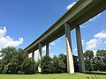
Twist Valley Bridge: View from the Twisteweg (cycle path; former Warburg – Sarnau railway )

Individual evidence
- ↑ a b c d e f g Brückentag with a difference ( memento from January 27, 2016 in the web archive archive.today ), see lower press release from June 26, 2006 (accessed on January 26, 2016), from cdu-volkmarsen.de
- ↑ a b c Twistetalbrücke (photo) on commons.wikimedia.org
- ↑ a b Bridge height above valley floor in meters (m) using differential measurements in Topographical Information Management, Cologne District Government, Department GEObasis NRW ( information ) ( DGK 5): approx. 224 m above sea level. NHN (⌀ height of the bridge center) minus 167 m above sea level NHN (Twiste altitude below the middle of the bridge) = 57 m
- ↑ a b Twiste Viaduct. In: Structurae , accessed on January 26, 2016, from structurae.de
- ↑ a b c d Topographical Information Management, Cologne District Government, Department GEObasis NRW ( information )
- ↑ Bridge center height in meters (m) above sea level (NHN) using differential measurements in Topographical Information Management, Cologne District Government , Department GEObasis NRW ( Notes ) ( DGK 5): 218.0 (north-west abutment) + 230.0 (south-east abutment) / 2 = 224 m