Teutleben (Hörsel)
|
Teutleben
Rural community of Hörsel
Coordinates: 50 ° 56 ′ 39 ″ N , 10 ° 33 ′ 40 ″ E
|
|
|---|---|
| Height : | 291 m above sea level NN |
| Area : | 7.82 km² |
| Residents : | 358 (Dec. 31, 2014) |
| Population density : | 46 inhabitants / km² |
| Incorporation : | December 1, 2011 |
| Postal code : | 99880 |
| Area code : | 03622 |
|
Location of Teutleben in Hörsel
|
|
Teutleben is a part of the rural community of Hörsel in the northwest of the Thuringian district of Gotha .
location
The total area of the Teutleben district is 782 hectares. It is west of the city of Gotha and is located in the Thuringian Basin . The Hörsel flows through the corridor and the federal road 7 touches the place and the district. The Erfurt - Eisenach railway line touches the area to the south .
history
Teutleben was first mentioned in writing in a document from the 9th century. In the year 819 (February 18) a certain Gertrud founded a nunnery in the village of Teitilebu (Teutleben), which she appropriated to the monastery in Fulda and only reserved the usufruct of the properties for life . However, on the way to Neufrankenroda, traces of the Aunjetitz culture were found with broken fragments .
From the 13th century the place belonged to the castle district of Tenneberg Castle near Waltershausen , from which the Tenneberg Office emerged . Teutleben belonged to the Duchy of Saxe-Gotha from 1640 , from 1672 to the Duchy of Saxe-Gotha-Altenburg and from 1826 to the Duchy of Saxe-Coburg and Gotha . From 1920 Teutleben was in the state of Thuringia .
On March 18, 1994, Teutleben was one of the seven founding communities of the Hörsel administrative community . By order of the Thuringian State Parliament on 16 November 2011, the administrative community Hörsel was dissolved on December 1, 2011, through a voluntary merger of ten previously independent municipalities Aspach , Ebenheim , Fröttstädt , Hörselgau , Laucha , Mechterstädt , Metebach , Teutleben, Trügleben and Weingarten the Rural community of Hörsel will be newly formed.
Population development
Development of the population (December 31st each) :
|
|
|
|
|
- Data source: Thuringian State Office for Statistics
politics
Former mayor
In the mayoral election in the Gotha district on June 6, 2010, Rainer Rudloff (Friends of the Fire Brigade) was elected honorary mayor of the community. His term of office began on July 1, 2010. With the conversion to a rural community, he became mayor of the district on December 1, 2011 (with a term of office until 2016).
- 1994–2010: Gerhard Stötzel (independent)
- 2010–2011: Rainer Rudloff (Friends of the Fire Brigade)
Culture and sights
Buildings
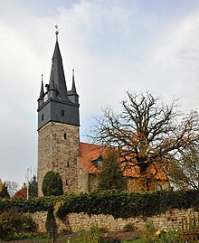
The church of St. Michaelis is a special attraction of the place. Together with the Church of St. Kilian in Laucha and the Church of St. Mary in Mechterstädt, it belongs to the Mechterstädt parish . The original church was built under Landgrave Albrecht in 1262. The present church was built by 1673/74 on the foundations of the previous building, and on October 16, 1674 as St. Michael 's Church inaugurated . The choir and nave of the church are the same width and have a half-barrel wooden ceiling. The galleries on the north and west walls stand on carved columns. Most of the painting on the church dates from 1719 (painter Johann Sebastian Preger (1676–1739) from Eisenach ). The baroque pulpit on the south wall is from 1675. The three-winged carved altar was created by an unknown master around 1500. In 1696 a new organ was installed, which was probably rebuilt by Knauf at the beginning of the 19th century . In 1986, the tower was re-slated. The church was last repaired in 1994 (roof structure and new roofing of the nave).
The tower offers a special feature: As in Mechterstädt and originally also in Schwarzhausen , the high spire is surrounded by four little turrets on the corners. The church is one of the protected cultural monuments in the Gotha district.
Individual evidence
- ↑ a b Leaflet of the Evangelical Lutheran. Parish office of the Mechterstädt parish
- ↑ Dr. August Beck: The history of the Gothaisches Land , Volume I, History of the Regents, Gotha, 1868. Here again reference is made to an older source: Schannat, Tradit. Fuldens. p. 127, no. 302. Pistorius SRG III. p. 585, no.105.
- ↑ Hörselbote - Official Gazette of the Hörsel Administrative Association, 9th year, No. 10/2011 ( page no longer available , search in web archives ) Info: The link was automatically marked as defective. Please check the link according to the instructions and then remove this notice. (PDF; 869 kB), ed. v. Administrative association "Hörsel", Hörselgau, November 25, 2011, p. 1
- ↑ StBA: Area changes from January 1st to December 31st, 2011
- ↑ Mayoral elections on June 12, 1994 in Thuringia - final result , Thuringian State Office for Statistics, Erfurt; Retrieved December 2, 2011
- ↑ Mayoral elections on June 13, 1999 in Thuringia - final result , Thuringian State Office for Statistics, Erfurt; Retrieved December 2, 2011
- ↑ Results of the mayoral elections , in: Local elections 2004 in Thuringia: Final results, elections of the mayors ( Memento from February 21, 2014 in the Internet Archive ) (PDF; 3.3 MB), ed. v. Thuringian State Office for Statistics, Erfurt, April 2008
- ↑ Mayoral elections on June 6, 2010 in Thuringia - final result , Thuringian State Office for Statistics, Erfurt; Retrieved December 2, 2011
Web links
- Teutleben on the side of the municipality of Hörsel


