
Tränkbach (Hegbach)
| Tränkbach | ||
 Tränkebach near Egelswoog |
||
| Data | ||
| Water code | DE : 239824 | |
| location | Offenbach district , district Gross-Gerau , Hessen ( Germany ) | |
| River system | Rhine | |
| Drain over | Hegbach → Schwarzbach → Rhine → North Sea | |
| source | in the Koberstädter Wald near Langen 49 ° 58 ′ 19 ″ N , 8 ° 42 ′ 42 ″ E |
|
| Source height | approx. 182.5 m above sea level NHN | |
| muzzle | before Mörfelden in den Hegbach Coordinates: 49 ° 58 '5 " N , 8 ° 35' 42" E 49 ° 58 '5 " N , 8 ° 35' 42" E |
|
| Mouth height | approx. 102 m above sea level NHN | |
| Height difference | approx. 80.5 m | |
| Bottom slope | approx. 9 ‰ | |
| length | 8.9 km | |
| Catchment area | 11.23 km² | |
The Tränkbach , also called Tränkebach , is an 8.9 km long, east-northeast and right tributary of the Hegbach . It flows in the Offenbach district and Groß-Gerau district in Hesse .
course
The Tränkbach rises in the Offenbach district in the Koberstädter Forest between Langen in the northwest, Egelsbach in the west-southwest and Offenthal in the east-northeast. Its source , taken in 1725, is located in the urban area of Langen about 775 m north of the Koberstädter Falltorhaus in the area of the Hallstatt group of grave mounds Koberstadt at about 182.5 m above sea level. NHN .
The upper course of the Tränkbach, which flows mainly in a westerly direction, near the source, passes the Ludwigsbrunnen and runs through the (upper) Egelswoog (pond) a few meters below it . Immediately afterwards it crosses under the federal motorway 661 , and to the west of it it flows through the Mittelste Egelswoog and then the (lower) Egelswoog .
On the eastern edge of Egelsbach, the Tränkbach crosses under the Darmstädter Landstrasse , which is part of the Bundesstrasse 3 a little further south ; The latter divides the route northwards from Egelsbach with the A 661. To the west of it it flows through the center of the municipality of Egelsbach and crosses under the Main-Neckar railway . Then the brook crosses under the county road 168. Then it takes up the brook of the curly beech , which passes the Bruchsee north shortly before its mouth . The stream flows through a meadow area lined with forest.
Shortly afterwards, from the Tränkbach - at its influence in the Groß-Gerau district - a 150 m long water link, located on the district border, branches off to the left to the Hegbach , a tributary of the Schwarzbach, which flows parallel to the south and also comes from the east . Slightly below this branch of the water, the brook in the urban area of Mörfelden-Walldorf crosses the federal motorway 5 .
Then the Tränkbach flows 100 m south of the Bornbruchsee and 1.6 km east above the outskirts of the Mörfelden district after the bridge of the Altschlagschneise dirt road over the creek at about 102 m above sea level in the Hegbach - at its 12.9 kilometers of water.
Catchment area, tributary and ponds
The catchment area (EZG) of the Tränkbach is 11.23 km². Its only major tributary is the stream from the krausen beech that flows west below Egelsbach ( GKZ = 2398242; left side, 5.6 km long, EZG = 6.97 km²).
On the upper course of the Tränkbach near the spring are (upper) Egelswoog , Mittelster Egelswoog and (lower) Egelswoog , which were created as a result of the spring collection carried out in 1725 in order to be able to entertain the hunting parties. Carp , tench , pike and white fish live in the ponds . The upper pond to the east is the largest of the three and measures around 120 m in length and around 30 m in width.
gallery
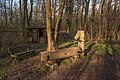
Ludwigsbrunnen with Heinrich Heim hut

(upper) Egelswoog

Middle Egelswoog
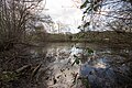
(lower) Egelswoog
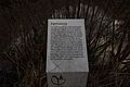
Information board Egelswoog


Individual evidence
- ↑ a b c d Map services of the Federal Agency for Nature Conservation ( information )
- ↑ a b c d e f Water map service of the Hessian Ministry for the Environment, Climate Protection, Agriculture and Consumer Protection ( information )
- ↑ a b Egelswoog (information board ), on commons.wikimedia.org