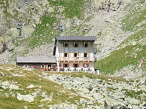
Tribulaunhütte (Italy)
| Tribulaunhütte (Italy) CAI hut |
||
|---|---|---|
|
Tribulaunhütte on the last meters of the ascent |
||
| location | On the Sandessee west of the Pflerscher Tribulaun ; South Tyrol , Italy ; Valley location: Innerpflersch | |
| Mountain range | Stubai Alps | |
| Geographical location: | 46 ° 59 '8.3 " N , 11 ° 19' 32.1" E | |
| Altitude | 2369 m slm | |
|
|
||
| owner | CAI - Sterzing Section | |
| Built | 1892 | |
| Construction type | hut | |
| Usual opening times | Early July to late September | |
| accommodation | 19 beds, 18 camps | |
| Winter room | 10 bearings | |
| Web link | Homepage of the hut | |
| Hut directory | ÖAV DAV | |
The Tribulaunhütte ( Italian Rifugio Cesare Calciati al Tribulaun ) is a mountain hut in the Stubai Alps in South Tyrol . It is located north above the Pflersch Valley at an altitude of 2369 m in the west of the Pflerscher Tribulaun . To the northwest of the hut is the Sandessee . A little less than 2½ kilometers away, in a north-easterly direction, beyond the Pflerscher Scharte in Austria there is a hut of the same name , which can be reached in 2 hours on foot.
history
The first small hut offered overnight accommodation for seven people and was inaugurated in 1892. Like the Magdeburger Hütte , which was built shortly before, this was built by the Magdeburg section of the DuÖAV . Two years after the inauguration, the section established the transition to the Magdeburger Hütte over the Hohen Zahn and through the southern flank of the Weisswandspitze , which is still widely used today . Since the hut, which was initially unmaintained, suffered considerable damage due to the high number and inattentiveness of the hikers, the Section in 1907 was forced to employ a hut keeper in the summer months. After the First World War , the section was expropriated by the Italian state without compensation and the hut was later handed over to the Cremona section of the CAI .
In 1949, both the Magdeburg and the Tribulaunhütte were handed over to the Sterzing section of the CAI. In 1953, planning began for an extension of the hut. The three-story extension was inaugurated in 1961. The hut was occupied by the military as early as 1964 after the attacks in South Tyrol and only returned to the Section in 1972.
Approach and tour options
The ascent to the hut starts from the Pflersch Valley . The highest starting point is the Stein car park (1450 m). From there it takes 3 hours to walk.
The Pflerscher Höhenweg , which begins at the hut and crosses the southern flank of the Tribulaun massif and leads to the Portjoch (2109 m), is very well known . Some sections of this four-hour walk are insured, a head for heights and surefootedness are necessary.
The three-hour transition to the Magdeburger Hütte, which is also known as the Kleiner Pflerscher Höhenweg , is also frequently used. The Hohe Zahn (2925 m) is crossed and the southern flank of the Weißwandspitze is crossed. The Weißwandspitze can be climbed via the south ridge with an additional effort of about an hour.
Both Pflerscher Höhenweg are part of the Tiroler Höhenweg . The 4th stage of the long-distance hiking trail starts in Obernberg and leads over the Portjoch to the hut. The 5th stage continues over the Magdeburger Hut to Innerpflersch.
The following peaks can be approached from the hut:
- Hoher Zahn (2925 m), 1½ hours
- Weißwandspitze (3017 m), 2½ hours
- Pflerscher Tribulaun (3097 m), 3 hours (only with climbing equipment)
- Pflerscher Pinggl (2766 m), 1½ hours
The transitions to the following huts are possible:
- Magdeburger Hut (2423 m), 3 hours
- Austrian Tribulaunhütte (2064 m), 2 hours over the Dolomieuweg, so named on the occasion of the Dolomieu celebration in 1989
- Bremer Hütte (2411 m), 6 hours
- Alpengasthof Obernbergersee (1593 m), 6 hours over the Portjoch
Geological features
Moraines
Immediately above the Tribulaunhütte, on the way to the Sandesjoch , two striking walls stand out: they run in a NW-SE direction and are about 190 m and 90 m long. A closer look at the heavily deposited sediments (carbonates and old crystalline rocks such as gneisses, amphibolites and mica schist predominate) the glacial character can be clearly determined: it is lateral moraines . The presence of a double wall with the same direction probably indicates the influence of two different phases of the ice advance.
Rock glacier
At the southern edge of the basin around the Sandessee the deposit forms of a fossil rock glacier can still be clearly seen . The rocks come from a Kar in the Vastelgruben (2578 m). The bouldery rock glacier is lobed, the frontal forehead pronounced and partly overgrown with moss and fern. Due to the vegetation and the location deep below the permafrost limit, recent ice activity is excluded.
Glacier cuts
Glacier cuts can be seen most clearly directly at the Tribulaunhütte or along the hiking trail to the Hohe Zahn (from an altitude of around 2700 m). There, relatively large areas have been cleared of the ground cover by the action of ice masses. These abrasion phenomena are clear indicators of glacier movements.
literature
- Walter Klier : Alpine Club Guide Stubai Alps . Bergverlag Rudolf Rother, Munich 2006, ISBN 3-7633-1271-4
Web links
- Tribulaunhütte in the historical Alpine archive of the Alpine associations in Germany, Austria and South Tyrol (temporarily offline)
Individual evidence
- ^ Egon Bernabè: Petrological and thermobarometric investigations on the Pflersch metabasite complex (Pflerschtal, South Tyrol - Italy). University of Innsbruck, 2009


