
Kreillerstraße underground station
| Kreillerstrasse | |
|---|---|
|
|
|
 Kreillerstrasse |
|
| Basic data | |
| District | Berg am Laim |
| Opened | May 29, 1999 |
| Tracks (platform) | 2 ( central platform ) |
| Coordinates | 48 ° 7 '33 " N , 11 ° 38' 49" E |
| use | |
| Stretch) | Trunk line 2 |
| Line (s) |
|
| Switching options |
|
The Kreillerstraße underground station was opened on May 29, 1999 and is located in the east of Munich in the Berg am Laim district . The station is under the street of the same name, which continues as the B 304 to Wasserburg . The back rail walls were clad with perforated aluminum panels, with motifs made of bricks on the walls. Behind them you can see a red wall. The ceiling is also provided with curved aluminum panels that reflect the light from the three light strips, only one of which is visible. The floor is covered with square granite slabs. At the west end of the train station, an elevator, escalators and fixed stairs lead to a barrier floor and further to the surface to the Kreillerstraße / St.-Veit-Straße intersection, where there is a connection to the tram . Tram line 19 went to Pasing until May 6, 2018 . Tram 21 has been running to Westfriedhof since October 29, 2018 . From the eastern end you can also use stairs to reach a barrier floor and from there Kreillerstraße.
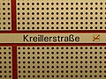
Station name on the back wall
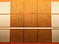
One of the brick motifs on the back rail walls

Platform level with curved aluminum panels on the ceiling

Ascent from the platform level to the distribution floor

Distribution level
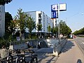
Surface access


| line | Line course |
|---|---|
|
|
Feldmoching - Hasenbergl - Dülferstraße - Harthof - Am Hart - Frankfurter Ring - Milbertshofen - Scheidplatz - Hohenzollernplatz - Josephsplatz - Theresienstraße - Königsplatz - Central Station - Sendlinger Tor - Fraunhoferstraße - Columbusplatz - Silberhornstraße - Untersbergstraße - Giesing - Karl-Preis-Platz - Innsbrucker Ring - Josephsburg - Kreillerstraße - Trudering - Moosfeld - Messestadt West - Messestadt East |
See also
Web links
- Further information at www.u-bahn-muenchen.de
- Area map and further information about the train station at mvv-muenchen.de