Vandré
| Vandré | ||
|---|---|---|

|
|
|
| local community | La motto | |
| region | Nouvelle-Aquitaine | |
| Department | Charente-Maritime | |
| Arrondissement | Rochefort | |
| Coordinates | 46 ° 3 ′ N , 0 ° 46 ′ W | |
| Post Code | 17700 | |
| Former INSEE code | 17457 | |
| Incorporation | 1st January 2018 | |
| status | Commune déléguée | |
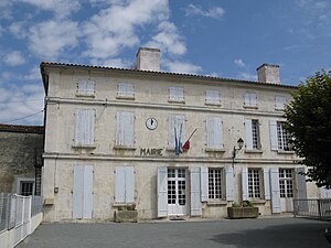
 Former town hall of Vandré |
||
Vandré is a former French community with 847 inhabitants (as of January 1 2017) in the department of Charente-Maritime in the region Nouvelle-Aquitaine . It belonged to the Arrondissement of Rochefort and the Canton of Surgères . The inhabitants are called Vandréens .
With effect from January 1, 2018, the previously independent municipalities of Vandré , Chervettes and Saint-Laurent-de-la-Barrière were merged to form Commune nouvelle La Devise and have the status of a Commune déléguée in the new municipality . The administrative headquarters are located in Vandré.
geography
Vandré is located about 22 kilometers east-southeast of La Rochelle in the historic Aunis region . Vandré is surrounded by the neighboring towns of Surgères in the north, Breuil-la-Réorte in the east and northeast, Chervettes in the east, Saint-Laurent-de-la-Barrière in the southeast, Genouillé in the south and west and Saint-Germain-de-Marencennes in the West and northwest.
Population development
| year | 1962 | 1968 | 1975 | 1982 | 1990 | 1999 | 2006 | 2013 |
| Residents | 564 | 602 | 646 | 678 | 745 | 725 | 732 | 823 |
| Source: Cassini and INSEE | ||||||||
Attractions
See also: List of Monuments historiques in La Devise
- Saint-Vivien church from the 13th century
literature
- Le Patrimoine des Communes de la Charente-Maritime. Flohic Editions, Volume 2, Paris 2002, ISBN 2-84234-129-5 , pp. 1094-1096.


