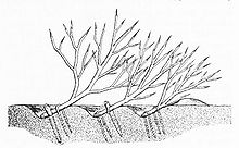
Russian spoil line

The Russian Verhaulinie ( Russian Засечная черта ) existed from about the 13th to the 18th century. This was a system of fortifications consisting of special afforestations, earth walls and a ring of fortified cities, which had been built on the southern and southeastern borders of the Grand Duchy of Moscow and later the Russian Tsar . This should repel the frequent attacks of the Turkic steppe nomads more effectively.
history
The use of Verhaulinien in Russian lands to protect against raids was first mentioned in Novgorod documents from the 12th century. By the 13th century at the latest, this type of border fortification was also common in other ancient Russian principalities. The first mentions of fortifications in the area of the Oka River , which were later expanded to form the Great Moscow Verhauline, come from this period .

Since the Russian principalities have always been attacked from the south and south-east in particular - the warriors of the Golden Horde and the Crimean Tatar state were particularly dangerous - it was especially after the development of the centralized Russian state in the 16th century that its southern borders for To make Tatars as impassable as possible. It is not known exactly when the construction of the Moscow Verhaulinine began, but existing fortifications were used in places. Finally, in 1566, during the reign of Tsar Ivan IV “the Terrible” , the border system was completed.
The Moscow Verhaulinie found its immediate use especially in the 16th century, when the southern borders of the Moscow state ran through the steppe areas south of the Oka. At the beginning of the 17th century, parts of the fortification could not withstand the attacks, as the Crimean Tatars intensified their attacks against the weakened Russia at the time when large parts of the tsarism were under Polish-Lithuanian occupation. The undamaged parts of the border fortifications were already out of date in the early 17th century, which prompted the Russian rulers to have the facilities expanded again in the 1630s. This work was financed by levying a special tax . There was still a few further expansion work on the Verhaulin line in the 1660s and 1670s; However, since by this time the borders of tsarism had already expanded far south, the old Verhaulin line lost its importance and was finally abandoned by the 18th century at the latest. Instead, new border fortifications were built in the late 17th century, for example near Simbirsk and in the area of the Kama River .
Location and characteristics
In the 16th and 17th centuries the line of spoilage of the Moscow state stretched roughly following the course of the Oka . Large parts of the border were in the area of today's oblasts Moscow , Kaluga , Tula , Oryol and Ryazan .
What exactly was used as a fortification largely depended on the topography and the natural environment. In many places, special forest strips were laid out, which in the event of a defense could quickly be felled towards the south and thus made an impenetrable obstacle for the attacker. In peacetime, such forest strips were protected by law from felling, and entry into the areas was forbidden except for specified passage points. In less wooded areas, artificial barriers were created instead of afforestation, for example earth or wooden walls. Often, however, natural obstacles, such as larger rivers and swamps, were also included in the line of defense. The total length of the Moscow Verha line was over 1000 kilometers in the 1630s. The artificial fortifications could have a width of up to 60 km in places.
The fortifications were supplemented by a ring of fortified cities stretching along the southern areas of Moscow, the core of which was typically an old Russian Kremlin . These fortified towns included Kolomna , Tula , Wenjow and Ryazan , among others . In total, over 40 cities belonged to this defensive ring.
In places, remains of the former fortifications have been preserved to this day. These include above all the former fortresses in the towns belonging to the Verhaulin line, but also remnants of forest strips and artificial systems. For example, the forest strips can still be seen in aerial photographs in some places. The remains of the border in the vicinity of Tula - the so-called "Tulaer Verhau" - are now a listed building.
Cartographic representations of the Russian spoil line
See also
Web links
- Article Засечные черты in the Great Soviet Encyclopedia (BSE) , 3rd edition 1969–1978 (Russian)
- Russian border fortification (Russian)


