
Administrative community Schwarzatal
| coat of arms | Germany map | |
|---|---|---|
 Help on coat of arms |
Coordinates: 50 ° 35 ' N , 11 ° 9' E |
|
| Basic data | ||
| Existing period: | 2019– | |
| State : | Thuringia | |
| County : | Saalfeld-Rudolstadt | |
| Area : | 128.14 km 2 | |
| Residents: | 8682 (Dec. 31, 2019) | |
| Population density : | 68 inhabitants per km 2 | |
| License plate : | SLF, RU | |
| Association key : | 16 0 73 5012 | |
| Association structure: | 10 municipalities | |
| Association administration address : |
Markt 5 in 98744 Schwarzatal |
|
| Website : | ||
| Community Chairman : | Ulf Ryschka | |
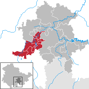
| Location of the Schwarzatal administrative community in the Saalfeld-Rudolstadt district | ||
  |
||

In the administrative community Schwarzatal from the Thuringian district of Saalfeld-Rudolstadt , the city of Schwarzatal and nine municipalities joined forces on January 1, 2019 to handle their administrative business. The administrative seat is the city of Schwarzatal.
The municipalities
- Cursdorf
- Deesbach
- Döschnitz
- Katzhütte
- Meura
- Rohrbach
- Schwarzatal , city
- Schwarzburg
- Sitzendorf
- Unterweißbach
history
The administrative community was formed on January 1, 2019 from the municipalities of the Bergbahnregion / Schwarzatal and Mittleres Schwarzatal administrative communities.
Individual evidence
- ^ Population of the municipalities from the Thuringian State Office for Statistics ( help on this ).
- ↑ Thuringian Law and Ordinance Gazette No. 14/2018 , accessed on May 20, 2019