Vielohmoor
The Vielohmoor was a moor in today's Hamburg-Schnelsen , which already existed in the Neolithic Age .
Surname
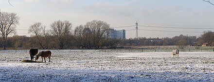
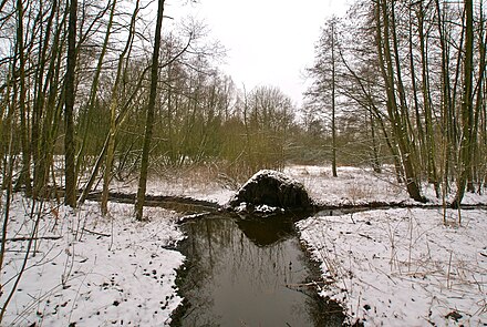
The name "Vielohmoor" is made up of the Low German words vie (= "break") and loh (= "grove"). Accordingly, Vieloh means "swamp forest". A map from the 18th century shows that the area was heavily forested . Today there are swampy meadows instead of the moor.
Geographical location
The Vielohmoor used to extend from the northeastern edge of Schnelsen to today's Hamburg state border and thus included the headwaters of the Kollau ; the northern part, on the other hand, was in the catchment area of the Mühlenau or Rellau , making the moor part of the watershed between the Alster and Pinnau . The entire moor area was therefore on the soil of the Pinneberg rule at that time . The new development area Niendorf-Nord is partly built on sandy elevations of the moor.
Vielohweg
In 1789 a path through the moor was planned for the first time to connect Schnelsen to the neighboring village of Niendorf . However, due to the boggy soil conditions, this project could not be carried out, so that the path only led into the Vielohmoor and the meadows there. In 1932 the moor was almost cut off and the project of a third connecting road from Schnelsen to Niendorf was completed after almost 150 years. Today the Vielohweg is one of the three main connecting roads to Niendorf, along with Wendlohstrasse and Frohmestrasse, and has been extended there to Sachsenweg.
Vielohwisch
Several spur streets lead off the Vielohweg ; one of them is the Vielohwisch, which leads to a housing estate built in the post-war period . The name is derived from the Low German Wisch (" meadow ") and indicates that the path ends deep in the Vielohwiesen.
Vielohkamp
The Vielohkamp was originally a connection between Vielohweg and Oldesloer Straße, but when the construction of the northernmost section of the Federal Motorway 7 began in 1967 , the road was shortened and has since ended in a bend. A small housing estate with six houses was built around the street in the early 1970s.
Sassenhoff
The Sassenhoff lies on the southern edge of the Vielohwiesen. Before the construction of the federal highway 447 in 1966, it connected the Frohmestrasse with the Wendlohstrasse and was therefore called "Ringstrasse" from 1906 to 1940. In 1789 there were three farms on this road , only one of which has survived today. This belonged to the Saß family. As this was the largest of the three courtyards , the family gave the street its name. Originally the Sassenhoff led deeper into the Vielohmoor, but this had to be shortened when the motorway was built in 1967. The old course of the Sassenhoff can still be recognized today by traces in the ground.
history
The Vielohmoor existed at least since the Neolithic Age. At the beginning of the 20th century , old possessions and travel items were found that date from this time. They are exhibited in the Schleswig-Holstein State Museum in Schleswig . In the Middle Ages , the Vielohmoor was an impassable area that was considered dangerous to enter. As part of the moor removal projects throughout Germany, the peat was systematically cut off in the Vielohmoor at the beginning of the 20th century . Individual remains can still be found on the former moorland today.
The gold neck ring
In 1856, the owner of farm 6, Mähl, found a splendid gold neck ring while cutting peat on the piece of the polychrome moor that belonged to him . It weighed 266 grams, had a diameter of 17 centimeters and was then worth 715 marks . The thickened ends show 29 or 31 punched snake ornaments , replicas of two adder without heads . The finder did not recognize the value at first and gave the ring to his children to play with. It was only when a peddler offered 3 marks for it that he became puzzled and made inquiries. Today the original of the gold circlet is also in the Schleswig-Holstein State Museum Schloss Gottorf . It is probably a dedication that was entrusted to the moor for religious reasons. The ring comes from the time after the Great Migration (6th - 8th centuries).
landscape
The landscape in the Vielohwiesen is swampy and has many kinks that separate the individual meadows from each other. The tree species are mainly poplars and beeches , there are no conifers . On the Schleswig-Holstein side of the area there are also small oak stocks . At the height of the Vietinghoffweg in Niendorf , the Vielohgraben and the Kollau come together. When it is foggy , the view of the Vielohwiesen from the Schnelsen side is very nice, because then you can only see the heads of the horses grazing on the meadows .
The Kollauteich , a retention basin of the Kollau , is also located in the Vielohwiesen.
Web links
Individual evidence
- ↑ http://www.schnelsenarchiv.de/11landkarten.htm
- ↑ a b Our Schnelsen a farming village from 1347 - 1975 (2008)
Coordinates: 53 ° 38 ′ 10.07 " N , 9 ° 55 ′ 56.21" E

