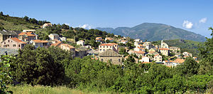
Murato
|
Murato Muratu |
||
|---|---|---|

|
|
|
| region | Corsica | |
| Department | Upper Corsica | |
| Arrondissement | Calvi | |
| Canton | Biguglia-Nebbio | |
| Community association | Nebbiu Conca d'Oro | |
| Coordinates | 42 ° 35 ' N , 9 ° 20' E | |
| height | 239-1,112 m | |
| surface | 20.38 km 2 | |
| Residents | 600 (January 1, 2017) | |
| Population density | 29 inhabitants / km 2 | |
| Post Code | 20239 | |
| INSEE code | 2B172 | |
 Murato |
||
Murato ( Corsican Muratu ) is a municipality with 600 inhabitants (as of January 1, 2017) on the island of Corsica in France . It is the capital of the Biguglia-Nebbio canton .
geography
In addition to the main settlement, Murato includes the villages Muratu Sopranu, Muratu Sottanu, Padulaccio, Cucinaja, Albarelle, Couvento, Milelli, Peru, San Giovanne, Costa di a Fornu, Campitale, Castagne, U Mucale, Poggiola and the hamlet Patronale.
The municipality of Murato is bordered by Vallecalle to the north and northeast , Rutali to the east, Scolca to the southeast, Campitello to the south, Bigorno to the southwest, Piève to the west and Rapale to the northwest .
Population development
| year | 1962 | 1968 | 1975 | 1982 | 1990 | 1999 | 2007 | 2016 |
|---|---|---|---|---|---|---|---|---|
| Residents | 534 | 538 | 538 | 533 | 565 | 555 | 592 | 601 |
Attractions
- Evangelical Church of San Giovanni
- San Michele de Murato Church
- A Nunziata Church
- War memorial
Personalities
- Joseph Fieschi , chief conspirator of the 1835 assassination attempt on King Louis-Philippe I , was born here on December 13, 1790.
Web links
Commons : Murato - collection of images, videos and audio files
