
Pietralba
|
Pietralba Petralba |
||
|---|---|---|
|
||
| region | Corsica | |
| Department | Upper Corsica | |
| Arrondissement | Calvi | |
| Canton | Golo-Morosaglia | |
| Community association | L'Île-Rousse Balagne | |
| Coordinates | 42 ° 33 ' N , 9 ° 11' E | |
| height | 251-1,520 m | |
| surface | 38.98 km 2 | |
| Residents | 504 (January 1, 2017) | |
| Population density | 13 inhabitants / km 2 | |
| Post Code | 20218 | |
| INSEE code | 2B223 | |
 Pietralba |
||

Pietralba ( Petralba in Corsican ) is a municipality on the French island of Corsica . It belongs to the Haute-Corse department , the Calvi arrondissement and the Golo-Morosaglia canton .
Geography, infrastructure
Pietralba is a scattered settlement 450 meters above sea level. Local peaks are Monte Astu (1535 m), Cima di Grimaseta (1509 m), Bocca di Tenda (1219 m), Monte Reghia di Pozzo (1469 m) and Monte Fossatello (1035 m). The Chemins de fer de la Corse train station of the same name is located in the Castifao district . The railway line and Route nationale 197 run along the municipal boundary. The village of Pietralba is through the department road D8 and the Route nationale in 1197 opened up. The neighboring communities are Lama in the north, Sorio and Piève in the northeast, Lento in the east, Canavaggia in the southeast, Castifao in the south and west and Novella in the northwest.
Population development
| year | 1962 | 1968 | 1975 | 1982 | 1990 | 1999 | 2008 | 2012 |
|---|---|---|---|---|---|---|---|---|
| Residents | 405 | 384 | 368 | 340 | 244 | 314 | 435 | 430 |

former station building
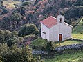
Chapel A Nunziata

Santa Maria Assunta Church

Saint-Roch church


