
Santo-Pietro-di-Tenda
|
Santo-Pietro-di-Tenda Santu Petru di Nebbiu |
||
|---|---|---|
|
||
| region | Corsica | |
| Department | Upper Corsica | |
| Arrondissement | Calvi | |
| Canton | Biguglia-Nebbio | |
| Community association | Nebbiu Conca d'Oro | |
| Coordinates | 42 ° 36 ' N , 9 ° 15' E | |
| height | 0-869 m | |
| surface | 125.66 km 2 | |
| Residents | 361 (January 1, 2017) | |
| Population density | 3 inhabitants / km 2 | |
| Post Code | 20217 | |
| INSEE code | 2B314 | |

Santo-Pietro-di-Tenda ( Corsican Santu Petru di Nebbiu ) is a commune in the French Haute-Corse on the island of Corsica . It belongs to the canton of Biguglia-Nebbio in the Arrondissement of Calvi .
geography
Santo-Pietro-di-Tenda borders the Mediterranean Sea to the north and the Gulf of Saint-Florent to the northeast . The neighboring communities are Piève in the east and San-Gavino-di-Tenda in the south and west. The main settlement consists of the villages of Santo-Pietra-di-Tenda and Casta. The former is located at the foot of the 648 m high Monte Brumica. The hamlets of Vezzio, Lavandaggio, Castagno, Pianello, Campiendi, Poggio and Corso also belong to the municipality.
Population development
| year | 1962 | 1968 | 1975 | 1982 | 1990 | 1999 | 2006 | 2012 |
|---|---|---|---|---|---|---|---|---|
| Residents | 557 | 540 | 316 | 286 | 291 | 332 | 333 | 356 |
Attractions
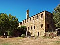
Saint Joseph Convent

Saint-Jean church
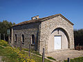
Saint-Pancrace Chapel

San Bastianu Chapel


economy
The vines in Santo-Pietro-di-Tenda are part of the Patrimonio wine-growing region .