
Monticello (Corsica)
|
Monticello Munticellu |
||
|---|---|---|
|
||
| region | Corsica | |
| Department | Upper Corsica | |
| Arrondissement | Calvi | |
| Canton | L'Île-Rousse | |
| Community association | L'Île-Rousse Balagne | |
| Coordinates | 42 ° 37 ′ N , 8 ° 57 ′ E | |
| height | 0-408 m | |
| surface | 10.64 km 2 | |
| Residents | 1,923 (January 1, 2017) | |
| Population density | 181 inhabitants / km 2 | |
| Post Code | 20220 | |
| INSEE code | 2B168 | |

Monticello ( Corsican Munticellu ) is a municipality in the Balagne on the French Mediterranean island of Corsica . It borders the Mediterranean Sea to the north and northeast and belongs to the Haute-Corse department , the Calvi arrondissement and the L'Île-Rousse canton . The neighboring communities are Occhiatana in the east, Ville-di-Paraso in the south-east, Speloncato in the south, Santa-Reparata-di-Balagna in the south-west and west and L'Île-Rousse in the north-west.
San Sebastianu Church

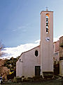
Saint-François church


Population development
| year | 1962 | 1968 | 1975 | 1982 | 1990 | 1999 | 2008 | 2012 |
|---|---|---|---|---|---|---|---|---|
| Residents | 237 | 237 | 251 | 500 | 944 | 1,253 | 1,708 | 1,740 |
Web links
Commons : Monticello (Haute-Corse) - Collection of images, videos and audio files