
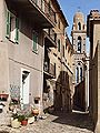
Speloncato
|
Speloncato U Spuncatu |
||
|---|---|---|
|
||
| region | Corsica | |
| Department | Upper Corsica | |
| Arrondissement | Calvi | |
| Canton | L'Île-Rousse | |
| Community association | L'Île-Rousse Balagne | |
| Coordinates | 42 ° 34 ′ N , 8 ° 59 ′ E | |
| height | 49-1,331 m | |
| surface | 17.67 km 2 | |
| Residents | 276 (January 1, 2017) | |
| Population density | 16 inhabitants / km 2 | |
| Post Code | 20226 | |
| INSEE code | 2B290 | |
 Speloncato |
||

Speloncato ( Corsican U Spuncatu ) is a municipality on the French island of Corsica . It belongs to the Corsica region , the Haute-Corse department , the Calvi arrondissement and the canton of L'Île-Rousse . The residents call themselves Spéloncatais or Spuncatacci .
geography
In the northeast, the Calvi - Ponte-Leccia railway line of the Chemins de fer de la Corse runs through the municipal marker with the stop “Le Regino”.
The dam of the Lac de Codole is located in the north-west of Speloncato.
The neighboring municipalities are Monticello in the north, Ville-di-Paraso in the east, Pioggiola in the south and Nessa , Feliceto and Santa-Reparata-di-Balagna in the west.
Population development
| year | 1962 | 1968 | 1975 | 1982 | 1990 | 1999 | 2008 | 2012 |
|---|---|---|---|---|---|---|---|---|
| Residents | 169 | 150 | 179 | 191 | 194 | 222 | 274 | 285 |

Former convent

Santa Maria Assunta Church
Tower of the Saint-Michel village church

Stop "Le Regino"


