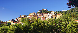
Oletta
| Oletta | ||
|---|---|---|
|
|
||
| region | Corsica | |
| Department | Upper Corsica | |
| Arrondissement | Calvi | |
| Canton | Biguglia-Nebbio | |
| Community association | Nebbiu Conca d'Oro | |
| Coordinates | 42 ° 38 ' N , 9 ° 21' E | |
| height | 0-959 m | |
| surface | 26.61 km 2 | |
| Residents | 1,696 (January 1, 2017) | |
| Population density | 64 inhabitants / km 2 | |
| Post Code | 20232 | |
| INSEE code | 2B185 | |
 Oletta |
||
Oletta is a municipality with 1696 inhabitants (as of January 1, 2017) on the island of Corsica in France . The residents call themselves Olettois .
In the north-west, the municipality extends up to 600 meters from the Gulf of Saint-Florent. The neighboring communities are Poggio-d'Oletta in the north, Furiani in the north-east, Biguglia in the east, Olmeta-di-Tuda in the south, Rapale in the south-west and Saint-Florent in the north-west.
Economy and Infrastructure
Oletta has approved vineyards in the Muscat du Cap Corse and Patrimonio wine-growing regions .
The department road D82 runs south of the town center and leads from Saint-Florent on the north coast of the island to the national road N193 ( Bastia - Ajaccio ).
Population development
| year | 1962 | 1968 | 1975 | 1982 | 1990 | 1999 | 2004 | 2017 |
|---|---|---|---|---|---|---|---|---|
| Residents | 620 | 619 | 692 | 892 | 879 | 830 | 1245 | 1696 |
Web links
Commons : Oletta - collection of images, videos and audio files
