
Feliceto
|
Feliceto U Fulgetu |
||
|---|---|---|
|
||
| region | Corsica | |
| Department | Upper Corsica | |
| Arrondissement | Calvi | |
| Canton | L'Île-Rousse | |
| Community association | L'Île-Rousse Balagne | |
| Coordinates | 42 ° 33 ' N , 8 ° 56' E | |
| height | 105-1,680 m | |
| surface | 15.25 km 2 | |
| Residents | 225 (January 1, 2017) | |
| Population density | 15 inhabitants / km 2 | |
| Post Code | 20225 | |
| INSEE code | 2B112 | |
 Feliceto |
||

Feliceto ( Corsican U Fulgetu ) is a municipality on the French island of Corsica . It belongs to the region of the same name , the Haute-Corse department , the Calvi arrondissement and the canton of L'Île-Rousse . The residents call themselves Fulgitinchi.
geography
Feliceto lies at about 300 meters above sea level in the Balagne and borders in the north with Santa-Reparata-di-Balagna , in the north-east with Speloncato , in the east with Nessa , in the south-east with Pioggiola , in the south-west with Zilia , in the west with Muro and in the northwest to Cateri and Sant'Antonino . The Lac de Codole reservoir is located in Feliceto, Santa-Reparata-di-Balagna and Speloncato, with the “Barrage de Codole” dam in the latter municipality. The municipality marker has a share in the Massif de Monte Grosso. Local elevations are called
- Scolca (285 m),
- Capu di Custa (286 m),
- Monte Longu (394 m),
- Capu ai Mori (455 m),
- Monte al Prato (924 m),
- Capu alla Forcella (1185 m),
- Cima di Cuzzia (1321 m),
- Cima Caselle (1622 m),
- San Parteo (1680 m),
- Punta di Accenata (1321 m).
Population development
| year | 1962 | 1968 | 1975 | 1982 | 1990 | 1999 | 2008 | 2012 |
|---|---|---|---|---|---|---|---|---|
| Residents | 206 | 181 | 160 | 145 | 145 | 162 | 210 | 204 |

Saint-Nicolas church
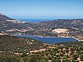
Lac de Codole reservoir

Strambolaccie district resp. E Strumbulacce


