
Santa-Reparata-di-Balagna
|
Santa-Reparata-di-Balagna Santa Riparata di Balagna |
||
|---|---|---|
|
||
| region | Corsica | |
| Department | Upper Corsica | |
| Arrondissement | Calvi | |
| Canton | L'Île-Rousse | |
| Community association | L'Île-Rousse Balagne | |
| Coordinates | 42 ° 36 ′ N , 8 ° 56 ′ E | |
| height | 35-561 m | |
| surface | 10.16 km 2 | |
| Residents | 1,012 (January 1, 2017) | |
| Population density | 100 inhabitants / km 2 | |
| Post Code | 20220 | |
| INSEE code | 2B316 | |
 Santa-Reparata-di-Balagna |
||

Santa-Reparata-di-Balagna ( Corsican Santa Riparata di Balagna ) is a municipality in Balagne on the French Mediterranean island of Corsica . It belongs to the Haute-Corse department , the Calvi arrondissement and the L'Île-Rousse canton . It borders in the north on L'Île-Rousse , in the north-east on Monticello , in the south-east on Speloncato , in the south on Feliceto , in the south-west on Sant'Antonino , in the west on Aregno and in the north-west on Corbara . In the southeast, the municipality mark has a share of the mountain lake Lac de Codole. The settlement area is on average 150 meters above sea level and consists of the villages Santa-Reparata-di-Balagna, Palmento and Occiglioni. The nearest train station is in L'Île-Rousse and is operated by the Chemins de fer de la Corse .
Population development
| year | 1962 | 1968 | 1975 | 1982 | 1990 | 1999 | 2008 | 2012 |
|---|---|---|---|---|---|---|---|---|
| Residents | 439 | 477 | 539 | 643 | 784 | 838 | 969 | 1.007 |
Attractions
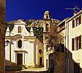
- Santa Riparata Church
- Saint-Roch church in the Occiglioni district
- Annunciation Chapel ( Chapelle de l'Annonciade ) in the Palmento district
- Chapel of Sainte-Marie in the district of Alzia
- Brotherhood chapel ( Chapelle de confrérie ) in the district of Saint-Antoine
- San Bernardino Chapel in the San Bernardinu district

Ruins of the former Sant Angelo convent

Annunciation Chapel
San Roccu Church (Saint-Roch)

Santa Reparata Church

Genoese tower Tour de Palmento


