Rutali
|
Rutali Rùtali |
||
|---|---|---|
|
|
||
| region | Corsica | |
| Department | Upper Corsica | |
| Arrondissement | Calvi | |
| Canton | Biguglia-Nebbio | |
| Community association | Nebbiu Conca d'Oro | |
| Coordinates | 42 ° 35 ' N , 9 ° 22' E | |
| height | 35-1,151 m | |
| surface | 17.11 km 2 | |
| Residents | 377 (January 1, 2017) | |
| Population density | 22 inhabitants / km 2 | |
| Post Code | 20239 | |
| INSEE code | 2B265 | |
| Website | http://www.rutali.fr/ | |
 View from Mount Astu to Rutali and its neighboring communities |
||
Rutali ( Corsican Rùtali ) is a French commune with 377 inhabitants (as of January 1, 2017) in the Haute-Corse department on the island of Corsica .
geography
Rutali is located in the northeast of the island of Corsica in the Nebbio region at an average altitude of 593 meters above sea level on a plateau in the Galghete forest about 8 kilometers from the coast of the Ligurian Sea and 22 kilometers southwest of Bastia , the seat of the prefecture of Haute-Corse department. The village is surrounded by the neighboring communities of Vallecalle , Murato and Vignale . The municipality has an area of 17.11 square kilometers. The local thoroughfare is the department road D305.
history
Since the end of the 11th century, Corsica was a fiefdom of the Republic of Pisa . In the 12th century the first Rutali seigneurs came from Volterra in Tuscany on behalf of Pisa . They administered the land between the Bevinco and Figareto rivers to the Biguglia lake . The name of the noble family was Rutali di Rutali Nebio in the 17th century .
The place Rutali was not mentioned in a document until 1254 in the copy book of the diocese of Nebbio. From 1447 to 1769 Corsica was a colony of the Republic of Genoa . Genoa relied several times on the help of France. In 1565 there were Corsican freedom fighters in Rutali, who were under the command of Sampiero Corso (1497–1567). The Genoese commander sent two companies from Saint-Florent to burn Rutali. The soldiers mistreated the local priest and took prisoners who were shipped to Genoa. In the 18th century, the Corsican resistance movement around Pascal Paoli elected its own king in 1736. Rutali was again affected by the rebellion. In 1743, the door of the Santa-Chjara chapel was broken open by French soldiers who were looking for Corsican rebels.
Not far from the Santa-Chjara chapel is a memorial to the victims of the 2009 civil defense helicopter crash in which five people died.
Population development
| year | 1962 | 1968 | 1975 | 1982 | 1990 | 1999 | 2007 | 2014 |
|---|---|---|---|---|---|---|---|---|
| Residents | 178 | 198 | 194 | 181 | 222 | 247 | 316 | 382 |
Culture and sights
The chapel Santa-Chjara was first mentioned in 1658. It stands northwest of the center in the forest of Galghete at an altitude of 800 meters above sea level. It is dedicated to Saint Clare of Assisi and was mentioned in a document in 1658. According to a local legend, the Santa-Chjara chapel is said to have been built after a miracle. Shepherds from Rutali were lost in a thick fog and prayed to Clare of Assisi, who then lifted the fog. An annual procession is held on August 12th, the day of the saint's remembrance .
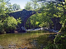
When Agostino Giustiniani (1470–1536) was Bishop of Nebbio, the Torreno Bridge already existed. This bridge leads over the Bevinco and stands with each of its pillars in a different municipality, in Rutali, Murato and Olmeta-di-Tuda .
Web links
Individual evidence
- ↑ Le village de Rutali. In: Annuaire-Mairie.fr. Retrieved September 11, 2011 (French).
- ↑ A Rustaghja: Crash de l'Hélicoptère Dragon 2B de la Sécurité Civile, en retour d'évacuation médicale. (No longer available online.) In: Le CorsicaBlog. April 26, 2009, archived from the original on February 9, 2012 ; Retrieved September 30, 2011 (French). Info: The archive link was inserted automatically and has not yet been checked. Please check the original and archive link according to the instructions and then remove this notice.

