Bigorno
|
Bigorno Bigornu |
||
|---|---|---|
|
|
||
| region | Corsica | |
| Department | Upper Corsica | |
| Arrondissement | Corte | |
| Canton | Golo-Morosaglia | |
| Community association | Marana-Golo | |
| Coordinates | 42 ° 32 ' N , 9 ° 18' E | |
| height | 132-1,107 m | |
| surface | 8.49 km 2 | |
| Residents | 90 (January 1, 2017) | |
| Population density | 11 inhabitants / km 2 | |
| Post Code | 20252 | |
| INSEE code | 2B036 | |
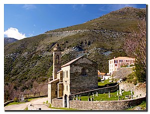
 Santa Maria Assunta Church |
||
Bigorno ( Corsican : Bigornu ) is a municipality with 90 inhabitants (as of January 1, 2017) in the Haute-Corse department on the French island of Corsica .
geography
The place is about 670 meters above sea level on the slope of a side valley of the Golo River , which forms the southern municipal boundary. The municipality is bordered by Piève to the north, Murato to the northeast, Campitello to the east, Bisinchi to the south and Lento to the west . The highest point is the Mont Pietrapolo with 1106 m. ü. M.
Attractions
- Church of the Assumption ( Santa-Maria Assunta ) from the 18th century
- War memorial
- Remains of Romanesque chapels : Santo Stefano, San Marcello and Sant'Agostino
Demographics
| year | 1962 | 1968 | 1975 | 1982 | 1990 | 1999 | 2007 | 2016 |
|---|---|---|---|---|---|---|---|---|
| Residents | 95 | 116 | 86 | 100 | 61 | 78 | 79 | 87 |
Regular events
On August 15th, Bigorno celebrates the Assumption of the Virgin Mary , the patronage of the Church.
economy
In the municipality there are controlled designations of origin (AOC) for Brocciu cheese, olive oil (Huile d'olive de Corse - Oliu di Corsica) , honey (Miel de Corse - Mele di Corsica) and chestnut flour (Farine de châtaigne corse - Farina castagnina corsa) and Protected Geographical Indications (IGP) for wine (Ile de Beauté blanc, rosé or rouge and Méditerranée blanc, rosé and rouge) .
Web links
Individual evidence
- ↑ Le village de Bigorno. In: Annuaire-Mairie.fr. Retrieved July 8, 2012 (French).
