
Erbajolo
| Erbajolo | ||
|---|---|---|
|
||
| region | Corsica | |
| Department | Upper Corsica | |
| Arrondissement | Corte | |
| Canton | Golo-Morosaglia | |
| Community association | Pasquale Paoli | |
| Coordinates | 42 ° 16 ' N , 9 ° 17' E | |
| height | 180-931 m | |
| surface | 15.45 km 2 | |
| Residents | 110 (January 1, 2017) | |
| Population density | 7 inhabitants / km 2 | |
| Post Code | 20212 | |
| INSEE code | 2B105 | |
 Erbajolo |
||

Erbajolo is a commune in the French Haute-Corse on the island of Corsica . It belongs to the canton of Golo-Morosaglia in the Arrondissement of Corte . The residents call themselves Erbajolais or Erbaghjulacci .
geography
Erbajolo is about 750 meters above sea level in the Corsican mountains. The neighboring municipalities are Sant'Andréa-di-Bozio in the northeast, Focicchia in the east, Altiani in the southeast, Venaco and Santo-Pietro-di-Venaco in the southwest, Riventosa and Poggio-di-Venaco in the west and Favalello in the northwest.
Population development
| year | 1962 | 1968 | 1975 | 1982 | 1990 | 1999 | 2008 | 2012 |
|---|---|---|---|---|---|---|---|---|
| Residents | 162 | 132 | 137 | 101 | 90 | 92 | 109 | 104 |
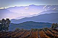
Grapevines near Erbajolo

Chapel of San Cristofanu
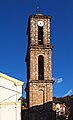
Tower of the Santa Maria Assunta Church


Web links
Commons : Erbajolo - collection of images, videos and audio files