
Castello di Rostino
| Castello di Rostino | ||
|---|---|---|
|
||
| region | Corsica | |
| Department | Upper Corsica | |
| Arrondissement | Corte | |
| Canton | Golo-Morosaglia | |
| Community association | Pasquale Paoli | |
| Coordinates | 42 ° 28 ' N , 9 ° 19' E | |
| height | 134-1,200 m | |
| surface | 12.4 km 2 | |
| Residents | 471 (January 1, 2017) | |
| Population density | 38 inhabitants / km 2 | |
| Post Code | 20235 | |
| INSEE code | 2B079 | |
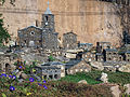
 Place view |
||

Castello-di-Rostino (Corsican Castellu di Rustinu ) is a French commune with 471 inhabitants (as of January 1, 2017) in the Haute-Corse department on the island of Corsica . It belongs to the Arrondissement of Corte and the canton of Golo-Morosaglia . The neighboring municipalities are Lento in the north-west and north, Bisinchi in the north-east and east, Ortiporio in the south-east, Morosaglia in the south, Valle-di-Rostino in the south-west and west and Canavaggia in the north-west.
The hamlet of Ponte Novu with the Genoese bridge of the same name belongs to Castello-di-Rostino . The battle of Ponte Novu took place here in 1769 .
Population development
| 1962 | 1968 | 1975 | 1982 | 1990 | 1999 | 2006 | 2013 |
|---|---|---|---|---|---|---|---|
| 303 | 320 | 286 | 274 | 252 | 277 | 343 | 420 |

Church Sainte-Marie

Parish Church of Saint Thomas


Bridge of Route nationale 193 over the Golo
Carriolu miniature village

