San Giuliano
| San Giuliano | ||
|---|---|---|
|
|
||
| region | Corsica | |
| Department | Upper Corsica | |
| Arrondissement | Corte | |
| Canton | Castagniccia | |
| Community association | Costa Verde | |
| Coordinates | 42 ° 19 ′ N , 9 ° 29 ′ E | |
| height | 0-295 m | |
| surface | 23.93 km 2 | |
| Residents | 726 (January 1, 2017) | |
| Population density | 30 inhabitants / km 2 | |
| Post Code | 20230 | |
| INSEE code | 2B303 | |
San-Giuliano ( Corsican San Ghjulianu ) is a French commune in the Haute-Corse department in Corsica with 726 inhabitants (as of January 1, 2017).
geography
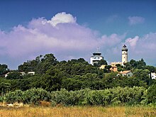
San-Giuliano is the easternmost municipality in the Haute-Corse department. It consists of numerous scattered villages , hamlets and homesteads from the Mediterranean coast to the mountainous hinterland. Its center is three kilometers from Cervione , 19 kilometers from Moïta and 34 km from Piedicroce near the mouth of the Alesani in the Mediterranean. The municipality of Alistro , whose lighthouse marks the easternmost point of Corsica, belongs to the municipality .
Population development
| year | 1962 | 1968 | 1975 | 1982 | 1990 | 1999 | 2007 | 2017 |
| Residents | 252 | 461 | 500 | 542 | 593 | 608 | 606 | 726 |
| Sources: Cassini and INSEE | ||||||||
economy
Since 1965, San-Giuliano has been the Corsican regional site of the French National Agronomy Research Organization , which is dedicated to research into the cultivation of citrus and exotic fruits.

