
Sermano
| Sermano | ||
|---|---|---|
|
||
| region | Corsica | |
| Department | Upper Corsica | |
| Arrondissement | Corte | |
| Canton | Golo-Morosaglia | |
| Community association | Pasquale Paoli | |
| Coordinates | 42 ° 19 ′ N , 9 ° 16 ′ E | |
| height | 407-1,420 m | |
| surface | 7.62 km 2 | |
| Residents | 63 (January 1, 2017) | |
| Population density | 8 inhabitants / km 2 | |
| Post Code | 20212 | |
| INSEE code | 2B275 | |
 Sermano |
||

Sermano , in Corsican "Sermanu", is a French commune in the Haute-Corse department in the Corsica region . It belongs to the Arrondissement of Corte and the canton of Golo-Morosaglia . The residents call themselves Sermanacci .
geography
Sermano is located on the island of Corsica, about 15 kilometers east of Corte , 762 meters above sea level. The northern tip of the municipality mark forms the highest point at 1420 m - the southwest slope of the Punta si San Cervone summit . The neighboring communities are
- Rusio in the northwest,
- Carticasi and Bustanico in the northeast,
- Alando in the east,
- Favalello in the south,
- Castellare-di-Mercurio to the west.
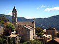
Church of the Annunciation ( Église de l'Annonciation )

Chapel of San Niculaiu resp. Saint-Nicolas


history
From 1954 Sermano was the main town (chief lieu) of the canton of Sermano. This also included the municipalities of Alando , Alzi , Bustanico , Castellare-di-Mercurio , Favalello , Mazzola , Sant'Andréa-di-Bozio , Santa-Lucia-di-Mercurio and Tralonca . He was replaced by the newly created canton of Bustanico in the early 1970s.
Population development
| year | 1962 | 1968 | 1975 | 1982 | 1990 | 1999 | 2008 | 2012 |
|---|---|---|---|---|---|---|---|---|
| Residents | 108 | 90 | 85 | 76 | 63 | 76 | 75 | 64 |