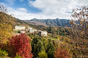
Tarrano
| Tarrano | ||
|---|---|---|
|
|
||
| region | Corsica | |
| Department | Upper Corsica | |
| Arrondissement | Corte | |
| Canton | Castagniccia | |
| Community association | Costa Verde | |
| Coordinates | 42 ° 21 ' N , 9 ° 24' E | |
| height | 466–1,050 m | |
| surface | 3.83 km 2 | |
| Residents | 16 (January 1, 2017) | |
| Population density | 4 inhabitants / km 2 | |
| Post Code | 20234 | |
| INSEE code | 2B321 | |
 Tarrano |
||
Tarrano , in Corsican Taranu, is a municipality on the French Mediterranean island of Corsica . It belongs to the Haute-Corse department , the Corte arrondissement and the Castagniccia canton .
geography
The settlement area is about 800 meters above sea level. Neighboring municipalities are Valle-d'Orezza in the north, Parata and Santa-Reparata-di-Moriani in the northeast, Felce in the east, Valle-d'Alesani in the southeast, Perelli in the south, Pietricaggio in the southwest, Piobetta in the west, Carcheto-Brustico in the West and north-west and Carpineto in the north-west.
Population development
| year | 1962 | 1968 | 1975 | 1982 | 1990 | 1999 | 2008 | 2012 |
|---|---|---|---|---|---|---|---|---|
| Residents | 136 | 121 | 41 | 16 | 23 | 27 | 14th | 15th |
Attractions
- Chapel of the Immaculate Conception ( Chapelle de l'immaculée Conception )
- Saint-Antoine-de-Padoue chapel
- Saint-Jean-Baptiste Chapel
- Saint-Gui church
- Romanesque church of San Vitus
Web links
Commons : Tarrano - collection of images, videos and audio files
