
Isolaccio-di-Fiumorbo
| Isolaccio-di-Fiumorbo | ||
|---|---|---|
|
||
| region | Corsica | |
| Department | Upper Corsica | |
| Arrondissement | Corte | |
| Canton | Fiumorbo Castello | |
| Community association | Communauté de communes de Fium'Orbu Castellu | |
| Coordinates | 42 ° 0 ′ N , 9 ° 17 ′ E | |
| height | 119–2,042 m | |
| surface | 40.89 km 2 | |
| Residents | 311 (January 1, 2017) | |
| Population density | 8 inhabitants / km 2 | |
| Post Code | 20243 | |
| INSEE code | 2B135 | |

Isolaccio-di-Fiumorbo ( Corsican L'Isulacciu di Fiumorbu ) is a municipality in the French department of Haute-Corse on the Mediterranean island of Corsica . It belongs to the canton of Fiumorbo-Castello in the Arrondissement of Corte . It is bordered by Ghisoni in the northwest , Poggio-di-Nazza in the north, Prunelli-di-Fiumorbo in the east, Serra-di-Fiumorbo in the southeast, San-Gavino-di-Fiumorbo in the south and Palneca in the west . The residents call themselves Isolacciais or Isulaccesi . The settlement area averages 740 meters above sea level and consists of the main town l'Isulacciu and the villages of Petrapole, Acciani and Ajola. The highest point in the municipality is the peak of Punta della Capella at 2042 m. ü. M.
Population development
| year | 1962 | 1968 | 1975 | 1982 | 1990 | 1999 | 2008 | 2012 |
|---|---|---|---|---|---|---|---|---|
| Residents | 550 | 451 | 332 | 411 | 346 | 333 | 393 | 361 |
Attractions
- baroque parish church of the Annunciation ( Église paroissiale de l'Annonciation )
- Chapel of Santa Lucia, a Romanesque building from the 9th century
- San Roccu Chapel, a baroque building
- Church in Pietrapola
- Chapel of Sainte-Marie in Acciani
- Chapel in Ajola
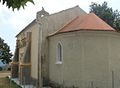
Chapel of Sainte-Marie in Acciani

Chapel in Ajola
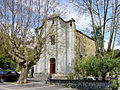
Church in Pietrapole


Personalities
- Don Jean Colombani (1903–1977), colonial administrator and diplomat