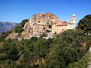
Tralonca
| Tralonca | ||
|---|---|---|
|
|
||
| region | Corsica | |
| Department | Upper Corsica | |
| Arrondissement | Corte | |
| Canton | Golo-Morosaglia | |
| Community association | Pasquale Paoli | |
| Coordinates | 42 ° 21 ′ N , 9 ° 12 ′ E | |
| height | 410-1,464 m | |
| surface | 15.7 km 2 | |
| Residents | 110 (January 1, 2017) | |
| Population density | 7 inhabitants / km 2 | |
| Post Code | 20250 | |
| INSEE code | 2B329 | |
 Tralonca |
||
Tralonca is a commune in the French Haute-Corse on the island of Corsica . It belongs to the canton of Golo-Morosaglia in the Arrondissement of Corte . The residents call themselves Traloncais or Tralunchesi.
geography
Tralonca is a scattered settlement at 756 meters above sea level in the Corsican mountains and is connected to the national road network by the D41. Neighboring communities are Soveria in the north-west, Omessa in the north, Lano and Rusio in the north-east, Santa-Lucia-di-Mercurio in the south-east and Corte in the south-west. The hamlets of Bistuglio and Pecorellu also belong to Tralonca.
Population development
| year | 1962 | 1968 | 1975 | 1982 | 1990 | 1999 | 2008 | 2012 |
|---|---|---|---|---|---|---|---|---|
| Residents | 127 | 92 | 73 | 74 | 48 | 64 | 93 | 102 |
Web links
Commons : Tralonca - collection of images, videos and audio files

