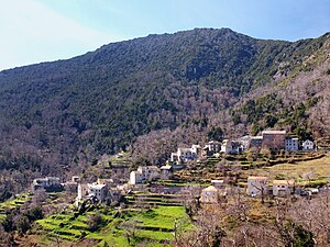
Ortiporio
| Ortiporio | ||
|---|---|---|
|
|
||
| region | Corsica | |
| Department | Upper Corsica | |
| Arrondissement | Corte | |
| Canton | Golo-Morosaglia | |
| Community association | Castagniccia Casinca | |
| Coordinates | 42 ° 27 ' N , 9 ° 21' E | |
| height | 313-1,236 m | |
| surface | 5.06 km 2 | |
| Residents | 127 (January 1, 2017) | |
| Population density | 25 inhabitants / km 2 | |
| Post Code | 20290 | |
| INSEE code | 2B195 | |
 Ortiporio |
||
Ortiporio is a French commune in the Haute-Corse on the island of Corsica . It belongs to the canton of Golo-Morosaglia in the Arrondissement of Corte .
geography
Are neighboring communities
- Crocicchia in the north and in the northeast,
- Penta-Acquatella in the northeast and in the east,
- Casabianca in the southeast,
- Giocatojo and Poggio-Marinaccio in the south,
- Morosaglia in the southwest,
- Castello-di-Rostino in the west,
- Bisinchi in the west and in the northwest.
Ortiporio is located at 650 meters above sea level in the north of the Castagniccia landscape in the Corsican mountains. Local elevations are called
- Monte Sant Angelo (1218 m),
- Cima au Borgu (930 m),
- Cima de Penta Frescaja (1114 m).
Population development
| year | 1962 | 1968 | 1975 | 1982 | 1990 | 1999 | 2006 | 2008 | 2012 |
|---|---|---|---|---|---|---|---|---|---|
| Residents | 193 | 167 | 119 | 100 | 104 | 113 | 123 | 126 | 131 |
Web links
Commons : Ortiporio - collection of images, videos and audio files


