Waalsprong
| province |
|
| local community |
|
|
Area - land - water |
13.45 km 2 11.21 km 2 2.24 km 2 |
| Residents | 18,475 (Jan 1, 2018) |
| Coordinates | 51 ° 52 ' N , 5 ° 51' E |
| Important traffic route |
|
| prefix | 024 |
| Postcodes | 6515, 6663 |
| Website | Homepage of Waalsprong |
| Location of Waalsprong in the municipality of Nijmegen | |
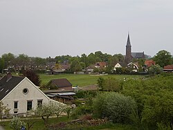
| Church in Lent | |
Waalsprong is a VINEX housing development in the Dutch municipality of Nijmegen . The name is a paraphrase of the district of Nijmegen-Noord , which includes the districts of Lent , Oosterhout and Ressen north of the Waal . 18,475 inhabitants live in an area of 13.45 km² (as of January 1, 2018).
history
The name Nijmegen-Noord appeared as early as the 1950s . Since the beginning of the 20th century, the population of Nijmegen has grown rapidly, so that the urban area was almost built over after the Second World War. Mayor Charles Hustinx emphasized, however, that "you will not build a Nijmegen-Noord like Arnhem developed an Arnhem-Zuid".
As the population continued to grow, thought was given to building a new residential area in the Ooijpolder , which in turn sparked great protest from the population. The then Minister for Housing rejected this idea.
In search of an alternative, Professor Wissink suggested “jumping over the Waal” and building a new district around the town of Lent , which at that time still belonged to the municipality of Elst , for 60,000 residents, which was to be named Laauwik . Since too much valuable land would be lost and the construction of a second Waal bridge would be too expensive, the decision was made to build new apartments in the Dukenburg and Lindenholt districts instead .
At the end of the 1980s , the urban area was completely built up, which is why, despite numerous contradictions, the municipalities of Valburg (today Overbetuwe ), Bemmel (today Lingewaard ) and Elst gave several hectares of land to Nijmegen between 1996 and 1998. The foundation stone for the building project was laid on January 19, 1998.
A new, rapidly growing VINEX system is being built in the country around Lent . According to initial plans, Nijmegen-Noord should consist of four sub-areas: both the densely populated area around Lent and the towns of Oosterhout and Ressen as well as an industrial area close to the A15 motorway . These plans have been adjusted several times over the years.
traffic

In the south, Waalsprong is connected to the city center via the N325 . In addition to the Waal bridge , De Oversteek has been another connection for car traffic since 2013 . The A15 runs north of the residential area and has two junctions (exit Elst and Knooppunt Ressen ) to the city district. In 2002 a temporary train station, Nijmegen Lent , located on the Arnhem – Nijmegen railway line and connected to the city center via the railway bridge , was opened. A final station was put into operation in 2013.
politics
Political structure
The Nijmegen-Noord district is divided into the following districts:
| No. a | place | Residents b | Area (in km²) | location | ||
|---|---|---|---|---|---|---|
| country | water | total | ||||
| 50 | Oosterhout | 6.220 | 2.48 | 0.59 | 3.07 |

|
| 60 | Ressen | 1,255 | 3.2 | 0 | 3.2 |

|
| 70 | Lent | 10,995 | 6.07 | 1.11 | 7.18 |

|
| 09 | Nijmegen-Noord | 18,475 | 11.75 | 1.7 | 13.45 |

|
Demographics
On January 1, 2018, 18,475 people lived in the Noord district, which is one of nine districts of the Nijmegen municipality . This means that around 10.5 percent of the Nijmegenaren live in Noord.
Population development
The population is growing rapidly, which can be attributed to the increasing housing construction, so that the population of the district has quintupled since 1999. The development of the population in detail can be found below:
| year | Residents |
|---|---|
| 1999 | 3,440 |
| 2001 | 4,940 |
| 2003 | 6,280 |
| 2004 | 6,400 |
| 2005 | 6,790 |
| 2006 | 8,380 |
| 2007 | 9,950 |
| 2008 | 10,500 |
| 2009 | 11,190 |
| 2010 | 11,825 |
| 2011 | 12,250 |
| 2012 | 12,475 |
| 2013 | 13,080 |
| 2014 | 13,795 |
| 2015 | 14,535 |
| 2016 | 15,410 |
| 2017 | 16,750 |
| 2018 | 18,475 |
Web links
swell
supporting documents
- Waalsprong In: Huis van de Nijmeegse geschiedenis (Dutch)
- Nijmegen Noord In: Nijmegen City (Dutch)
- StatLine In: opendata.cbs.nl . Centraal Bureau voor de Statistiek (Dutch)
Single receipts
- ↑ a b c d Kerncijfers wijken en buurten 2018 Centraal Bureau voor de Statistiek , accessed on August 1, 2018 (Dutch)
- ↑ Stadsbrug De Oversteek feestelijk geopend. In: Nijmegen Nieuws. November 23, 2013, accessed May 14, 2018 (Dutch).
- ↑ Nijmegen Lent In: treinstationinfo.nl, accessed on May 14, 2018 (Dutch)
- ↑ Kerncijfers wijken en buurten 2017 Centraal Bureau voor de Statistiek , accessed on August 1, 2018 (Dutch)


