
St. Gallenkappel
| St. Gallenkappel | ||
|---|---|---|
 |
||
| State : |
|
|
| Canton : |
|
|
| Constituency : | Sea gaster | |
| Political community : | Eschenbach SG | |
| Postal code : | 8735 | |
| former BFS no. : | 3337 | |
| Coordinates : | 716 930 / 234 382 | |
| Height : | 595 m above sea level M. | |
| Area : | 19.46 km² | |
| Residents: | 1839 (December 31, 2012) | |
| Population density : | 95 inhabitants per km² | |
| Website: | www.stgallenkappel.ch | |
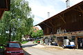
 St. Gallenkappel from the car, taken on Rickenstrasse |
||
| map | ||
|
||


Until December 31, 2012, St. Gallenkappel was a political municipality in the canton of St. Gallen in the constituency of See-Gaster . On January 1, 2013, it merged with Eschenbach and Goldingen to form the new municipality of Eschenbach .
geography

The former municipality of St. Gallenkappel is located about three kilometers north of Uznach , or between Wattwil and Rapperswil-Jona and consisted of the villages of St. Gallenkappel, Rüeterswil and Walde.
The village of St. Gallenkappel at about 570 m above sea level. M. consists of the hamlets Würzengässli, Berg, Gerendingen, Oberrain, Gwadt, zum Spycher, Rössliwies, Dorf, Oberdorf, Kronenwiese, Holz and Betzikon. Rüeterswil at about 700 m with its 383 inhabitants consists of the hamlets of Obermatten and Dorf. Walde at 840 m altitude has 239 inhabitants and consists of Widen, Dorf, Rütihalde and Oberricken .
The highest point in the community was the Tweralpspitz at 1331 m above sea level. M. , the deepest in the Aabachtobel with 439 m .
population
| Population development | |
|---|---|
| year | Residents |
| 1850 | 1229 |
| 1900 | 1008 |
| 1950 | 1110 |
| 1980 | 1234 |
| 2000 | 1719 |
| 2010 | 1806 |
history
The community was called Rüeterswil until the 18th century. The village of St. Gallenkappel did not come into being until around 1750. Where the parish church stands today, a Gallus chapel was probably built as early as the 9th century, which was dedicated to St. Gallus and gave the place its name.
Attractions
- The parish church of St. Laurentius and St. Gallus

Entrance to Walde

Church of St. Anthony of Padua in Walde

Interior view of the Antonius Church

Entrance to Rüeterswil

St. Ursula Chapel in Rüeterswil

Interior view of the St. Ursula Chapel
The hamlet of Feldli

reel
_173.JPG)
_178.JPG)
_183.JPG)
_157.JPG)
_160.JPG)
_162.JPG)
_148.JPG)
_147.JPG)
Personalities
- Alfredo Battistini (1953–2008), sculptor, draftsman and sportsman
- Peter Gross (* 1941), sociologist
- Rolf Knie (* 1949), painter, artist and actor
Web links
- Official website of the municipality of St. Gallenkappel
- Alois Stadler: Sankt Gallenkappel. In: Historical Lexicon of Switzerland .
Individual evidence
- ↑ Entry in the Historical Lexicon of Switzerland, see web links
- ^ Benno Schubiger: St. Gallenkappel SG. Parish Church of St. Laurentius and St. Gallus. (Swiss Art Guide, No. 267). Ed. Society for Swiss Art History GSK. Bern 1980, ISBN 978-3-85782-267-4 .
Amden | Benken | Eschenbach | Gommiswald | Kaltbrunn | Rapperswil-Jona | Schänis | Schmerikon | Uznach | Weesen
Former communities: Ernetschwil | Goldingen | Jonah | Rapperswil | Vineyards | St. Gallenkappel
Canton of St. Gallen | Constituencies of the Canton of St. Gallen | Municipalities of the Canton of St. Gallen