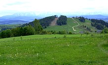
Wdżar
| Wdżar | ||
|---|---|---|
|
Wdżar from the south |
||
| height | 767 m npm | |
| location | Poland | |
| Mountains | Czorsztyner Pieninen , Pieninen , Carpathian Mountains | |
| Coordinates | 49 ° 27 '22 " N , 20 ° 19' 11" E | |
|
|
||
| Type | Rock peaks | |
| rock | Volcanic rock | |
The Wdżar is a mountain in the Polish Middle Pienines , a mountain range of the Pieninen , 767 meters high. It is in the Czorsztyn Pienines . The summit lies between the Pienines and the Gorce , which is why it is partly included in the latter. Geologically, it does not fit either with the one or the other, as it is an extinct volcano that was formed between the Pieninen rock belt and the Beskids ( Outer Carpathians ). It is usually also dealt with in tourist guides about the respective mountains.
Location and surroundings
The Wdżar is located above the place Kluszkowce on the northern edge of the Jezioro Czorsztyńskie reservoir . To the north of the summit lies the Lubań massif . In the summit area there are three quarries where andesite was mined. Andesite rocks also lie south of the summit. Thanks to the special mineral-rich volcanic rock and the orientation to the south, a unique flora has also formed on the southern slopes of the mountain, which you cannot otherwise find in the vicinity. Provincial road 969 runs from Nowy Targ to Nowy Sącz below the summit .
etymology
Sometimes you can also find the names: Wzor, Wżar, Wżary, Żar, Zdżar, Zżar and Wzory. The etymology of the name is not clear.
natural reserve
The Wdżar lies outside the Pieniny National Park and the Gorce National Park . Consideration is being given to protecting the andesite rocks and their flora in a nature reserve.
tourism
The Wdżar is easily accessible for tourists due to the good transport connections and is very popular as a destination. There is a cable car from Kluszkowce, as well as a summer toboggan run, an adventure park, a bike park, a downhill park and the Czorsztyn-Ski ski area, as well as several hiking trails and nature trails. There are also several restaurants on the mountain and around it. The rocks in the quarries are also often used by climbers. The summit area serves as a starting point for paragliders . The first Polish records for paragliding were set here in the 1970s and 1980s.
From the summit there is a wide panorama of the Podhale , Spiš and Orava regions and the surrounding mountain ranges:
in the North
in the East
in the south
in the southwest
in the West
- Babia Góra in the Saybuscher Beskids
Routes to the summit
Marked routes to the summit lead from Szczawnica and Czorsztyn :
- ▬ a blue-marked hiking trail from Kluszkowce over the Przełęcz Snozka mountain passto the summit and on to the Lubań into the Gorce .
- ▬ a green educational trail from Kluszkowce across the Wąwóz Papieski gorgeto the top.
Web links
literature
- Witold Henryk Paryski, Zofia Radwańska-Paryska: Wielka encyklopedia tatrzańska. Wydawnictwo Górskie, Poronin 2004, ISBN 83-7104-009-1 .
- Józef Nyka: Pieniny. Przewodnik. 9th edition. Trawers, Latchorzew 2006, ISBN 83-915859-4-8 .
- Pieniny polskie i słowackie. Mapa turystyczna 1:25 000. Agencja Wydawnicza "WiT" sc, Piwniczna 2008, ISBN 978-83-907671-3-0 .
panorama


