
Weißler height
| Weißler height
(Weißlerhöhe)
|
||
|---|---|---|
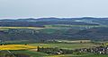
 View from Obertiefenbach over the Hasenbach valley east-north-east to the Weißler Höhe (back); the right of the curtain wall hang the upper Tiefenbacher Weiler Spriestersbach |
||
| height | 456.2 m above sea level NHN | |
| location | between Mittelfischbach , Oberfischbach and Niedertiefenbach ; Rhein-Lahn-Kreis , Rhineland-Palatinate ( Germany ) | |
| Mountains | Taunus | |
| Dominance | 4.75 km → Gray head | |
| Coordinates | 50 ° 15 '11 " N , 7 ° 55' 55" E | |
|
||
| particularities | Ringwall Weißler Höhe | |

The Weißler Höhe , also called Weißlerhöhe , is 456.2 m above sea level. NHN high elevation in the Taunus . It is located near Oberfischbach in the Rhein-Lahn district in Rhineland-Palatinate . Remains of the Weißler Höhe ring wall lie on the summit region .
geography
location
The Weißler Höhe rises in the western Hintertaunus in the Nassau Nature Park . Its summit is 3.5 km southwest of Katzenelnbogen , 2.1 km west of Mittelfischbach , 1.7 km west-north-west of Oberfischbach , 2.5 km north-north-west of Rettert , 2.5 km east of Niedertiefenbach , 0.9 km south-south-east of its District of Hof Bleidenbach and 3 km southeast of Roth . The survey is located in the eastern part of the Einrich in the state forest Katzenelnbogen .
To the north, the landscape of the Weißler Höhe slopes down to the Dörsbach . The Hasenbach tributary Grundbach rises south of the mountain . From Katzenelnbogen - over the north face of the mountain near the summit and past the Bleidenbach farm - the district road 51 leads to Roth. About 1.3 km southwest of the mountain summit, east of the Obertiefenbach hamlet Spriestersbach, rises the mountain ring wall ( 448.9 m ).
Natural allocation
The Weißler Höhe belongs to the natural spatial main unit group Taunus (No. 30), in the main unit Westlicher Hintertaunus (304) and in the subunit Katzenelnbogen plateau (304.9) to the natural area Central Katzenelnbogen plateau (304.92). To the northwest and west, the landscape falls into the natural area of Lower Dörsbach-Tiefenbach area (304.91).
Worth seeing
About 0.6 km southwest of the summit of the Weißler Höhe lies the Wildweiberhöhle, a natural monument, on the upper reaches of the Grundbach near the source . Their rock formation is a folded quartzitic sandstone / Taunus quartzite layer of the Lower Devonian .
Ringwall Weißler Höhe
The Weißler Höhe ring wall is located near the summit . The remains are only faintly visible in the area and stand out as a stony earth step with a maximum height of 1 m. It can be assumed that the ramparts were used as a quarry and thus fell victim to road construction, among other things. The rampart itself was located here on the hilltop, which slopes gently on all sides.
View from the Heisebäumchen vantage point near Dachsenhausen eastwards to the Weißler Höhe (center)

Summit of the Weißler Höhe with wayside cross and survey point; Looking north


See also
Individual evidence
- ↑ a b Map service of the landscape information system of the Rhineland-Palatinate Nature Conservation Administration (LANIS map) ( notes )
- ↑ Heinrich Müller-Miny, Martin Bürgener: Geographical land survey: The natural spatial units on sheet 138 Koblenz. Federal Institute for Regional Studies, Bad Godesberg 1971. → Online map (PDF; 5.7 MB)
- ↑ Geopark Westerald-Lahn-Taunus: Rock of the Year 2012: Quartzite ( Memento from July 8, 2015 in the web archive archive.today ), from geopark-wlt.de