West Windsor (Vermont)
| West Windsor | ||
|---|---|---|
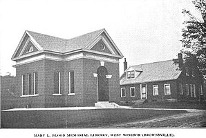
 Brownsville Library around 1901 |
||
| Location in Vermont | ||
|
|
||
| Basic data | ||
| Foundation : | October 26, 1848 | |
| State : | United States | |
| State : | Vermont | |
| County : | Windsor County | |
| Coordinates : | 43 ° 28 ′ N , 72 ° 30 ′ W | |
| Time zone : | Eastern ( UTC − 5 / −4 ) | |
| Residents : | 1,099 (as of 2010) | |
| Population density : | 17.2 inhabitants per km 2 | |
| Area : | 64.0 km 2 (approx. 25 mi 2 ) of which 63.8 km 2 (approx. 25 mi 2 ) are land |
|
| Height : | 321 m | |
| Postal code : | 05089 | |
| Area code : | +1 802 | |
| FIPS : | 50-83050 | |
| GNIS ID : | 1462257 | |
| Website : | www.WestWindsorVT.govOffice2.com | |
West Windsor is a town in Windsor County in the state of Vermont in the United States with 1,099 inhabitants (according to the 2010 census).
geography
Geographical location
West Windsor lies in the eastern foothills of the Green Mountains above the Connecticut River valley . Mount Ascutney , around 1,000 meters high, is the highest point in the area. A large number of small watercourses run through the area, which is mainly used for dairy and sheep farming. The main settlement, Brownsville (until 1848 West Windsor , but renamed West Windsor when the Town was formed) is the main settlement of the area, a politically and administratively dependent village .
Neighboring communities
All distances are given as straight lines between the official coordinates of the places from the 2010 census.
- North: Hartland , 8.0 km
- East: Windsor , 5.7 miles
- South: Weathersfield , 2.4 mi
- Southwest: Cavendish , 6.9 mi
- West: Reading , 6.8 mi
- Northwest: Woodstock , 4 miles
climate
The snowfalls between October and May (with a peak of around 45 cm in January) are around two meters, about twice as high as the mean snow depth in the USA. The daily sunshine duration is at the lower end of the range in the USA.
history
The town emerged on October 26, 1848 from the division of the original Windsor Town . The rural part located in the mountains was separated as West Windsor from the eastern, more urban part on the river bank and the major traffic routes. The cause was a long-running dispute over the cost of travel and poor relief. Such a division had already taken place: on November 4, 1814, the Vermont Congress had already decided to separate the two towns; but it was reversed on March 1, 1816 after the underlying disputes had been settled.
Since the mid-1960s, Mount Ascutney has been gradually expanded into a tourist center with cross-country trails, ski lifts and a hotel. Cyclocross races have also been held in November for a number of years .
In September 2011, Cyclone Irene hit the community and caused heavy rainfall. The small river Mill Brook overflowed its banks and lifted one of Vermont's last covered bridges , the Bowers Bridge , from its foundations and carried it with it. The historic bridge was so badly damaged that it had to be replaced by a new construction. It is adapted to the appearance of the original bridge. A model of the 15-meter-long bridge had already been given to the city administration after it was destroyed.
Population development
| Census Results - Town of West Windsor, Vermont | ||||||||||
|---|---|---|---|---|---|---|---|---|---|---|
| year | 1800 | 1810 | 1820 | 1830 | 1840 | 1850 | 1860 | 1870 | 1880 | 1890 |
| Residents | 1002 | 924 | 708 | 690 | 570 | |||||
| year | 1900 | 1910 | 1920 | 1930 | 1940 | 1950 | 1960 | 1970 | 1980 | 1990 |
| Residents | 513 | 569 | 514 | 512 | 494 | 504 | 539 | 571 | 763 | 923 |
| year | 2000 | 2010 | 2020 | 2030 | 2040 | 2050 | 2060 | 2070 | 2080 | 2090 |
| Residents | 1067 | 1099 | ||||||||
Economy and Infrastructure
traffic
The community has no direct connection to trunk roads; but a country road leads into the valley of the Connecticut River with connections to Interstate 91 and US Route 5 .
Public facilities
West Windsor has no other public facilities other than normal city administration. The nearest churches and a clinic can be found in neighboring Windsor.
education
West Windsor is part of the Windsor Southeast Supervisory Union with Hartland, Windsor and Weathersfield .
There is an elementary school in Brownsville.
Web links
- Homepage of the municipality (English)
- Profile of the municipality on the official portal www.Vermont.gov
- Entry on VirtualVermont (English) ( Memento from March 26, 2017 in the Internet Archive )
Individual evidence
- ^ West Windsor in the United States Geological Survey's Geographic Names Information System , accessed October 1, 2014
- ↑ Population data from the 2010 US Census in the American Factfinder
- ↑ Coordinates of the locations of the Census Authority 2010
- ↑ Climate data at www.City-Data.com (English)
- ↑ Historical summary on the homepage of the municipality (English)
- ^ Photo of the remnants of the historic bridge by Loren Fisher
- ↑ Report on the town's homepage, accessed on March 25, 2011
- ↑ Population 18500–2010 according to census results
- ^ Windsor Southeast Supervisory Union , accessed June 11, 2017

