Wildgerlosspitze
| Wildgerlosspitze | ||
|---|---|---|
|
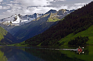
The Wildgerlosspitze is the fourth mountain from the left, seen from the Gerlosstausee |
||
| height | 3280 m above sea level A. | |
| location | Border Tyrol / Salzburg , Austria | |
| Mountains | Zillertal Alps | |
| Dominance | 1.04 km → Reichenspitze | |
| Notch height | 140 m ↓ notch to Reichenspitze | |
| Coordinates | 47 ° 8 '39 " N , 12 ° 5' 52" E | |
|
|
||
| First ascent | August 19, 1877 by Victor Sieger and Stefan Kirchler from the south | |
The Wildgerlosspitze is a rugged mountain in the Reichenspitzgruppe , a mountain group in the eastern Zillertal Alps . It lies exactly on the border between the Austrian federal states of Tyrol and Salzburg . The Wildgerlosspitze has two peaks; the main summit with 3280 m above sea level. A. Höhe is the second highest point of the group behind the Reichenspitze and the north-west summit, also called Signalspitze in old literature , is about 13 meters lower. The Wildgerlosspitze sends pronounced ridges to the southeast and west, the south ridge is only short. The peak was first climbed from the south on August 19, 1877 by the tourist Victor Sieger and the mountain guide Stefan Kirchler.
Location and surroundings
The Wildgerlosspitze lies in the west-east running main ridge of the Reichenspitz group. Neighboring mountains in the ridge running to the east are the Hahnenkamm with 3209 meters high and the 3303 meter high Reichenspitze. The west ridge, called Schönachschneid , carries the 3209 meter high Schneekarspitze and the Zillerkopf at 2995 meters. The little pronounced south ridge ends in the 3214 meter high Kuchelmooskopf . North of the Wildgerlosspitze extends the extensive and crevice-rich Wildgerloskees . In the south, the Zillerkees and Kuchelmooskees glaciers stretch up to an altitude of 3200 meters. The closest localities are in the south of Prettau in the Ahrntal , about eleven kilometers as the crow flies, and in the north of Gerlos , which is a good nine kilometers away.
Bases and routes
The path of Sieger and his mountain guide Kirchler in 1877 led from the Kuchelmoosalpe to the south , today sunk in the reservoir Zillergründl , over the saddle between Kuchelmooskopf and Wildgerlosspitze. Today's normal route is the easiest ascent and basically follows the route taken by the rope team from 1877. The Plauener Hut at 2363 meters serves as a base . The path leads over the south ridge, which is covered with blocks, and at one point requires climbing skills of UIAA grade III , otherwise UIAA II. The transition to the lower north-west summit of the Wildgerlosspitze has the difficulty UIAA IV- in extremely fragile rock.
Literature and map
- Carl Diener in Eduard Richter : The Development of the Eastern Alps , Volume III, Verlag des Deutschen und Oesterreichischen Alpenverein, Berlin 1894
- Heinrich and Walter Klier : Alpine Club Guide Zillertal Alps , Bergverlag Rother , Munich 1996, ISBN 3-7633-1269-2
- Alpine Club Map 1: 25,000, sheet 35/3, Zillertal Alps, east
Individual evidence
- ^ Austrian Map online 1: 50,000 (ÖK 50) of the BEV
- ^ A b Heinrich and Walter Klier : Alpenvereinsführer Zillertaler Alpen , Munich 1996, ISBN 3-7633-1269-2 , p. 424
- ↑ Carl Diener in: Eduard Richter : The development of the Eastern Alps , Volume III, Berlin 1894, p. 84

