
Wissenkerke
 flag |
 coat of arms |
| province |
|
| local community |
|
|
Area - land - water |
11.79 km 2 11.42 km 2 0.37 km 2 |
| Residents | 1,145 (Jan. 1, 2017) |
| Coordinates | 51 ° 35 ′ N , 3 ° 45 ′ E |
| Important traffic route |
|
| prefix | 0113 |
| Postcodes | 4486, 4491, 4493-4494 |
 |
|
Wissenkerke is a village in the municipality of Noord-Beveland in the Dutch province of Zeeland . The population is 1,145 (as of January 1, 2017). Until 1995 Wissenkerke was an independent municipality, which also included Kamperland and Geersdijk . Since 1995 Wissenkerke has been the administrative seat of the then newly formed community of Noord-Beveland. There are several campsites and the Sophiahaven marina in Wissenkerke .
Wissenkerke is mentioned as a parish as early as 1242 . The exact location of this ancient science is not exactly known. In 1352 the village had to be relocated after a flood . In 1530 and on November 2, 1532, Noord-Beveland was hit by two storm surges , the latter also washing away Wissenkerke. Only the church tower was preserved and stood on the foreland of the dike to the Oosterschelde for several years .
In 1652 the area was polded again . The dike around the Wissenkerkepolder was closed, and the current village was finally rebuilt according to plan with parcels arranged at right angles . Shortly after 1670 a new church was built. The new Wissenkerke had a port on the Cruijckelcreke , a creek that ran east of the village and whose outflow from the Wissenkerkepolder lay on the southern edge of the polder. This creek continued to silt up and the harbor disappeared first in 1697, then in 1719 and finally in 1771, when the area was further polded. In 1860 the grain mill De Onderneming (German: " The company ") was built, the mill Landzigt (" Landsicht ") dates from 1869.
In the 1930s , the discussion about a municipal reorganization began , whereby Wissenkerke should have merged with Colijnsplaat , Kats and Kortgene in a new (large) municipality Kortgene . In 1941 this merger came about in principle, but without Wissenkerke, which then remained independent for the time being. It was not until 1995 that Kortgene and Wissenkerke merged to form the then new municipality of Noord-Beveland , of which Wissenkerke has been the administrative center since then .
photos
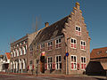
Monumental building

Mill: korenmolen de Onderneming

Former mill: korenmolen het Landzigt


badges and flags
The Wissenkerke coat of arms shows a red, diamond-shaped buckle on a silver (white) background. It was derived from the coat of arms of the Van Wissenkercke family . On September 6, 1853, it was set as the municipal coat of arms.
The flag consists of three stripes in blue, white and black. The white stripe contains the red buckle from the municipal coat of arms. The blue stripe refers to the old coat of arms of Kamperland , the black to that of Geersdijk .
Born in Wissenkerke
- Aart Jacob Marcusse (1868–1933), Hoofdcommissaris of Amsterdam (roughly equivalent to a German police chief )
- Eduard Flipse (1896–1973), conductor and composer
- Marinus Flipse (1908-1997), pianist
- Dirk Jan Koets (1895–1956), painter
Web links
- Wissenkerke: Website of the tourist association VVV Zeeland (German, Dutch, English)
Individual evidence
- ↑ a b Kerncijfers wijken en buurten 2017 Centraal Bureau voor de Statistiek , accessed on April 7, 2018 (Dutch)
De Banjaard | Colijnsplaat | Geersdijk | Kamperland | Kats | Kortgene | Plankendorp | Stroodorp | Wissenkerke