Yeongyang
| Yeongyang-gun | |||
|---|---|---|---|
| Korean alphabet : | 영양군 | ||
| Chinese characters : | 英 陽 郡 | ||
| Revised Romanization : | Yeongyang-gun | ||
| McCune-Reischauer : | Yŏngyang-gun | ||
| Basic data | |||
| Province : | Gyeongsangbuk-do | ||
| Coordinates : | 36 ° 40 ′ N , 129 ° 7 ′ E | ||
| Surface: | 815.14 km² | ||
| Residents: | 17.198 (as of 2019) | ||
| Population density : | 21 inhabitants per km² | ||
| Structure: | 1 eup, 5 myeon | ||
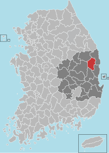
| map | |||
|
|||
The county Yeongyang ( kor. : 영양군 , Yeongyang-gun ) is located in the province of Gyeongsangbuk-do in South Korea . The administrative headquarters are in Yeongyang-eup City. The district had an area of 815.14 km² and a population of 17,198 inhabitants in 2019. The area of the district is mountainous with deep gorges and only 10 percent of the land is cultivable. The population density is among the lowest in South Korea. The district is known for growing apples and chili peppers.

Location of the county in Gyeongsangbuk-do
