Bonghwa
| Bonghwa gun | |||
|---|---|---|---|
| Korean alphabet : | 봉화군 | ||
| Chinese characters : | 奉化 郡 | ||
| Revised Romanization : | Bonghwa gun | ||
| McCune-Reischauer : | Ponghwa-gun | ||
| Basic data | |||
| Province : | Gyeongsangbuk-do | ||
| Coordinates : | 36 ° 53 ' N , 128 ° 44' E | ||
| Surface: | 1,201 km² | ||
| Residents: | 32,464 (as of 2019) | ||
| Population density : | 27 inhabitants per km² | ||
| Structure: | 1 eup, 9 myeon | ||
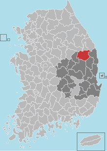
| map | |||
|
|||
Bonghwa County ( kor .: 홍성군 , Bonghwa-gun ) is located in Gyeongsangbuk-do Province in South Korea . The administrative headquarters are located in the city of Bonghwa-eup. The district had an area of 1,201 km² and a population of 32,464 inhabitants in 2019.
The county is inland on the northern edge of the province and borders on Gangwon Province in the north . It is bounded by Yeongyang and Uljin counties to the east, Andong to the south and Yeongju to the west . Bongwha is surrounded by the Taebaek and Sobaek Mountains . Bonghwa has a colder climate than most of the province with an average annual temperature of 10 degrees Celsius.
Sons and daughters of the county
- Kim Ki-duk (* 1960), filmmaker

Location of the county in Gyeongsangbuk-do
