
Zalakomár
| Zalakomár | |||||
|
|||||
| Basic data | |||||
|---|---|---|---|---|---|
| State : | Hungary | ||||
| Region : | Western Transdanubia | ||||
| County : | Zala | ||||
| Small area until December 31, 2012 : | Zalakaros | ||||
| District since 1.1.2013 : | Nagykanizsa | ||||
| Coordinates : | 46 ° 32 ' N , 17 ° 11' E | ||||
| Area : | 54.88 km² | ||||
| Residents : | 3,039 (Jan 1, 2011) | ||||
| Population density : | 55 inhabitants per km² | ||||
| Telephone code : | (+36) 93 | ||||
| Postal code : | 8751 | ||||
| KSH kódja: | 10348 | ||||
| Structure and administration (status: 2018) | |||||
| Community type : | Large community | ||||
| Structure : | Zalakomár, Kiskomárom, Komárváros, Ormándpuszta | ||||
| Mayor : | Tamás Csárdi (independent) | ||||
| Postal address : | Tavasz et al. 13 8751 Zalakomár |
||||
| Website : | |||||
| (Source: A Magyar Köztársaság helységnévkönyve 2011. január 1st at Központi statisztikai hivatal ) | |||||


Zalakomár is a Hungarian large village in the district Nagykanizsa in Zala county . The districts of Kiskomárom , Komárváros and Ormándpuszta belong to the large municipality .
Geographical location
Zalakomár is located about 15 kilometers northeast of the city of Nagykanizsa . Neighboring communities are Balatonmagyaród , Zalakaros , Galambok and Somogysimonyi.
history
Today's large municipality was created in 1969 through the merger of the places Kiskomárom and Komárváros .
Community partnerships
-
 Berekfürdő , Hungary
 -
 Krásnohorské Podhradie , Slovakia
-
 Lukino Selo (Лукино Село), Serbia
-
 Пийтерфолво , Ukraine
-
 Sâncrăieni , Romania
Attractions
-
Roman Catholic Church Szentháromság , built 1744–1772, with wall paintings by István Dorfmeister , in the district of Kiskomárom
- The organ of the church was built in 1866 by Lajos Mooser
- Roman Catholic Chapel Nepomuki Szent János , built in 1754
- Water buffalo reserve ( Bivalyrezervátum ), northeast of the village
traffic
The main road No. 7 runs through Zalakomár, which is joined by roads No. 6805 and No. 6831. The M7 motorway runs east of the town . The large community is connected to the railway line from Budapest Ostbahnhof to Nagykanizsa.
photos

Ormándpuszta cemetery
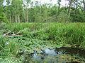
Wetland near Zalakomár

Water buffalo reserve


Web links
- Official website ( Hungarian )
- Zalakomár at tourinform.hu (Hungarian)