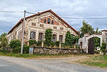
Zehuby
| Zehuby | ||||
|---|---|---|---|---|
|
||||
| Basic data | ||||
| State : |
|
|||
| Region : | Středočeský kraj | |||
| District : | Kutná Hora | |||
| Municipality : | Žleby | |||
| Area : | 316 hectares | |||
| Geographic location : | 49 ° 52 ' N , 15 ° 29' E | |||
| Height: | 270 m nm | |||
| Residents : | 59 (2011) | |||
| Postal code : | 286 01 | |||
| License plate : | S. | |||
| traffic | ||||
| Street: | Ronov nad Doubravou - Hostovlice | |||
Zehuby (German Sehub , also Zehub ) is a district of the municipality Žleby in the Czech Republic . It is located eight kilometers southeast of Čáslav and belongs to the Okres Kutná Hora .
geography
Zehuby is located by the Zehubský creek in the Čáslavská kotlina ( Czaslau basin ).
Neighboring towns are Žleby and Velký Dvůr in the north, Ronov nad Doubravou in the northeast, Biskupice and Mladotice in the east, Kněžice and Kamenné Mosty in the southeast, Hostačov , Skryje and Okřesaneč in the south, Hostovlice , Vystrkov and Bratčice in the southwest, Medun and Horkyice in the west Drobovice , Filipov, Markovice and Bažantnice u Sv. Anny in the northwest.
history
The first mention of Zehubi took place in 1284, when the Prague bishop Tobias of Bechyně at the request of Wilamower Abbot Jaroslav ecclesiastical duties in Zehubi the Pleban Chechon ( CEC ) in Markovice transferred. In 1370, Marquard and Peter Kost von Wartenberg , who had inherited the Žleb rule from the widow Agnes von Žleb, founded a Cistercian monastery in Žleb , which they endowed with extensive income from the Zehuby and Trubsko estates. After the destruction of the monastery by the Taborites in 1427 was landtäflige Hof Zehuby reunited with the rule Žleb. From 1736 Josef von Schönfeld and from 1746 the princes Auersperg belonged to the owners . In 1787 there were 25 houses in Zehub and Žehuby . In the years 1823–1824, the communities of Hostaulitz , Sehub and Wokřesanec built a joint contribution grain floor in Hostaulitz at their own expense.
In 1840 the rustic village of Sehub or Zehub in the Caslauer Kreis consisted of 26 houses in which 185 people lived. There was a manorial farm , a dominical sheep farm and an inn in the village . The one-layer Medun, consisting of a manorial pheasantry and a hunter's house, was consolidated after Sehub . The parish and administrative center was Žleb. Until the middle of the 19th century, Sehub remained subject to the allodial rule of Žleb.
After the abolition of patrimonial Zehuby formed from 1849 with the district Kamenné Mosty a municipality in the judicial district of Časlau . From 1868 the place belonged to the Časlau district . In 1869 Zehuby had 255 inhabitants and consisted of 27 houses. In 1900 there were 258 people in Zehuby, in 1910 there were 250. In 1930 Zehuby had 213 inhabitants and consisted of 43 houses. In 1943 the Zehuby-Kamenné Mosty volunteer fire brigade was founded. During the territorial reform of 1960, the municipality was assigned to the Okres Kutná Hora . In 1961 it was incorporated into Žleby . In the 2001 census, 49 people lived in the 36 houses in the village.
Local division
The districts of Zehuby and Kamenné Mosty form the cadastral district of Zehuby.
Attractions
- Sandstone cross and wooden bell tree on the village square
literature
- Historický lexikon obcí České republiky 1869–2005 , part 1, p. 122
Individual evidence
- ↑ http://www.uir.cz/katastralni-uzemi/797642/Zehuby
- ↑ https://www.monasterium.net/mom/CZ-NA/RBB/51/charter
- ↑ Jaroslaus Schaller : Topography of the Kingdom of Bohemia. Sixth part. Czaslauer Kreis Prague and Vienna 1787, p. 93
- ^ Johann Gottfried Sommer : The Kingdom of Bohemia; Represented statistically and topographically. Volume 11: Caslauer Kreis. Ehrlich, Prague 1843, p. 30.
- ↑ https://sdh-zehuby-kmosty.webnode.cz/historie/
- ↑ http://www.uir.cz/katastralni-uzemi/797642/Zehuby


